Approximate Location Map
Large Map »
Latitude: 51.6899 / 51°41'23"N
Longitude: 0.3175 / 0°19'3"E
OS Eastings: 560285
OS Northings: 201557
OS Grid: TL602015
Mapcode National: GBR YC.0QQ
Mapcode Global: VHHMQ.GS6D
Plus Code: 9F32M8Q8+XX
Entry Name: Boundary Wall Extending West and South West from Church of St Laurence Belfry to Gateway
Listing Date: 9 December 1994
Grade: II
Source: Historic England
Source ID: 1197162
English Heritage Legacy ID: 373311
ID on this website: 101197162
Location: Blackmore, Brentwood, Essex, CM4
County: Essex
District: Brentwood
Civil Parish: Blackmore, Hook End and Wyatts Green
Built-Up Area: Blackmore
Traditional County: Essex
Lieutenancy Area (Ceremonial County): Essex
Church of England Parish: Blackmore St Laurence
Church of England Diocese: Chelmsford
Tagged with: Wall
BLACKMORE
TL6001 CHURCH STREET
723-1/15/14 Boundary wall extending W & SW from
Church of St Laurence belfry to
gateway
GV II
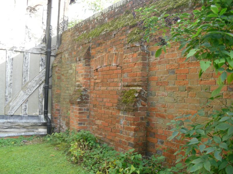
Boundary wall. Early C18, altered in C19. Red and blue brick
in Flemish bond. Abuts on SW corner of belfry of Church of St
Laurence (qv) and extends westwards for approximately 10m to a
blocked gap one metre wide, and there turns in a short radius
curve to the SSW, as far as a gateway immediately N of the
moat, a distance of approximately 115m.
The C18 section is from, and including, this curve. Blue
headers form a regular pattern on both sides. 65m SW of the
belfry is a recess on the E side within a wider recess, the
whole being 13m wide; the inner corners are square, the outer
corners form short radius curves in header bond. At the S end
the wall forms a reversed quadrant of approximately 1.50m
radius to a square pier of the gateway (blocked with a wooden
fence). The short section S of the gateway, abutting on a
brick bridge over the moat, is not of architectural interest.
No buttresses on either side. Has been raised twice with red
brick. The lowest course of the first raise is of long bricks
in stretcher bond on both sides, the bricks being up to 0.40m
long. Plain copings of bricks on edge at each raise. The S
part of the double recess has been damaged, probably by a
falling tree, and repaired in plain red bricks, one of which
is inscribed TMCL 1919 on the W side. The reversed quadrant at
the S end has been repaired at both top corners with modern
bricks and cement mortar. The section immediately W of the
belfry is of a later build, similar in quality and style to
the wall N of the E end of Blackmore Church with a blocked
doorway with segmental arch 2m from the belfry and 5
buttresses on the N side, 4 of which have 2 roll mouldings and
tumbled courses at the reductions. Similar coping. The main
part of the wall is a rare survival in exceptionally good
order.
Listing NGR: TL6028501557
External links are from the relevant listing authority and, where applicable, Wikidata. Wikidata IDs may be related buildings as well as this specific building. If you want to add or update a link, you will need to do so by editing the Wikidata entry.


Other nearby listed buildings
