Latitude: 51.6947 / 51°41'40"N
Longitude: 0.3202 / 0°19'12"E
OS Eastings: 560454
OS Northings: 202098
OS Grid: TL604020
Mapcode National: GBR NJD.PRQ
Mapcode Global: VHHMQ.HNMQ
Plus Code: 9F32M8VC+V3
Entry Name: The Woodbines
Listing Date: 20 February 1976
Last Amended: 9 December 1994
Grade: II
Source: Historic England
Source ID: 1197168
English Heritage Legacy ID: 373326
ID on this website: 101197168
Location: Blackmore, Brentwood, Essex, CM4
County: Essex
District: Brentwood
Civil Parish: Blackmore, Hook End and Wyatts Green
Built-Up Area: Blackmore
Traditional County: Essex
Lieutenancy Area (Ceremonial County): Essex
Church of England Parish: Blackmore St Laurence
Church of England Diocese: Chelmsford
Tagged with: Architectural structure
BLACKMORE
TL60SW FINGRITH HALL LANE
723-1/2/22 (East side)
20/02/76 The Woodbines
(Formerly Listed as:
BRENTWOOD
FINGRITH HALL LANE, Blackmore
The Woodbines)
II
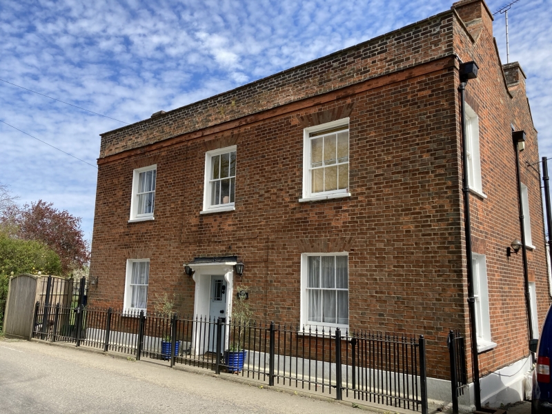
House. Early C19. Red brick in Flemish bond, roofed with
handmade red clay tiles. 2 parallel ranges, forming an almost
square plan facing W, with a stack in each gable of each
range.
EXTERIOR: 2 storeys. Single storey lean-to to rear right.
Ground floor, 2 mid-C19 sashes of 3+3 vertical lights, without
horns, with flat arches of gauged brick. First floor, 3
similar sashes. Central 6-panel door, the top panels glazed,
with marginal lights, other panels flush; flat canopy on
profiled brackets; stone step flush with ground, with 2
cast-iron bootscrapers set in it. Band of rubbed bricks at
base of parapet. The left elevation has on the ground floor a
C20 bow, and on the first floor 2 sashes of 6+6 lights (one
with horns) with similar arches; the rear window is
substantially lower than the front window. Parapet gables. The
right elevation has on the ground floor one similar sash (with
horns), the other altered to a C20 French window, retaining
the original brick arch and jambs; and on the first floor 2
similar sashes (with horns). The date 1816 is inscribed in a
brick, about 3m above ground level. The rear elevation has on
the first floor 3 sashes of 6+6 lights with segmental brick
arches. Date 1841 is reported to be inscribed in this wall.
Listing NGR: TL6045402098
External links are from the relevant listing authority and, where applicable, Wikidata. Wikidata IDs may be related buildings as well as this specific building. If you want to add or update a link, you will need to do so by editing the Wikidata entry.


Other nearby listed buildings