Latitude: 51.62 / 51°37'12"N
Longitude: 0.3021 / 0°18'7"E
OS Eastings: 559465
OS Northings: 193754
OS Grid: TQ594937
Mapcode National: GBR XN.GV9
Mapcode Global: VHHN3.6J1Y
Plus Code: 9F32J8C2+2R
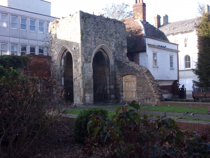
Entry Name: Ruins of Old Chapel of St Thomas a Becket
Listing Date: 21 October 1958
Grade: II
Source: Historic England
Source ID: 1197221
English Heritage Legacy ID: 373468
ID on this website: 101197221
Location: Brentwood, Essex, CM14
County: Essex
District: Brentwood
Electoral Ward/Division: Brentwood North
Parish: Non Civil Parish
Built-Up Area: Brentwood
Traditional County: Essex
Lieutenancy Area (Ceremonial County): Essex
Church of England Parish: Brentwood St Thomas
Church of England Diocese: Chelmsford
Tagged with: Chapel
BRENTWOOD
TQ5993 HIGH STREET 723-1/12/77 (South side) 21/10/58 Ruins of old chapel of St Thomas a Becket
II
Chapel. Founded c1221 by the Abbot of St Osyth for the use of the abbey's tenants. Walls of irregular ragstone and flint pebbles, indurated conglomerate blocks in lower courses. Much repair with thin tile courses. Plan was rectangular nave and smaller rectangular chancel, now outlined in C20 dwarf brick walls. Only lower part of W end with tower base in NW angle and a small section of N wall remain. 2 centred arched doorways, W door and N door (adjacent to tower) had similar mouldings - wave and double ogee divided by a cavetto. 2 centred tower arches to E and S now have restored heads with residual plain chamfers, cavetto and reinstated outer wave mouldings. The W elevation has diagonal outer buttresses and 2 inner ones set equally along the face. Although degraded they have stone dressings with split flint panels. Within tower, lower part of newel staircase in NW angle with stair light through W wall, entry through door with 4 centred arched head. The creasing line of the nave roof where it abutted the tower is evident on the tower E face. The doorway mouldings show that the building was rebuilt in the mid-later C14. The tower, with related mouldings was contrived into the NW angle soon after. The presence of indurated conglomerate in the lower courses, tailing off above, suggests an origin earlier than 1221. In Essex churches it is used as a major walling material in the Norman period (cf St Edmund and St Mary, Ingatestone (qv)). The foundation of 1221 may have been a re-dedication of an earlier building which either then, or in the later C14, was rebuilt keeping the same plan for the nave but having flint and ragstone as the principal material for the upper, disturbed courses. The building served as a chapel until 1835, and later as the Boys National School, until 1869 when it was largely dismantled. In 1835 a new chapel was built on the site of the present parish church, followed by the present church in 1881. The chapel is a Scheduled Ancient Monument. (Central and SW Essex : Monument 1: 31; Guide to Parish Church of St Thomas of Canterbury: 5; The Buildings of England: Pevsner N: Essex: 1965-: 101).
Listing NGR: TQ5946593754
External links are from the relevant listing authority and, where applicable, Wikidata. Wikidata IDs may be related buildings as well as this specific building. If you want to add or update a link, you will need to do so by editing the Wikidata entry.


Other nearby listed buildings