Latitude: 51.6703 / 51°40'13"N
Longitude: 0.3841 / 0°23'2"E
OS Eastings: 564961
OS Northings: 199532
OS Grid: TQ649995
Mapcode National: GBR NJW.7XQ
Mapcode Global: VHJKD.L8YV
Plus Code: 9F32M9CM+4M
Entry Name: Cranwell House
Listing Date: 20 February 1976
Last Amended: 9 December 1994
Grade: II
Source: Historic England
Source ID: 1197301
English Heritage Legacy ID: 373674
ID on this website: 101197301
Location: Ingatestone, Brentwood, Essex, CM4
County: Essex
District: Brentwood
Civil Parish: Ingatestone and Fryerning
Built-Up Area: Ingatestone
Traditional County: Essex
Lieutenancy Area (Ceremonial County): Essex
Church of England Parish: Ingatestone St Edmund and St Mary
Church of England Diocese: Chelmsford
Tagged with: House
INGATESTONE AND FRYERNING
TQ6499 HIGH STREET, Ingatestone 723-1/14/389 (North West side)
20/02/76 No.102
Cranwell House
(Formerly Listed as
BRENTWOOD
HIGH STREET, Ingatestone
(North West side) No.102
Cranwell)
GV II
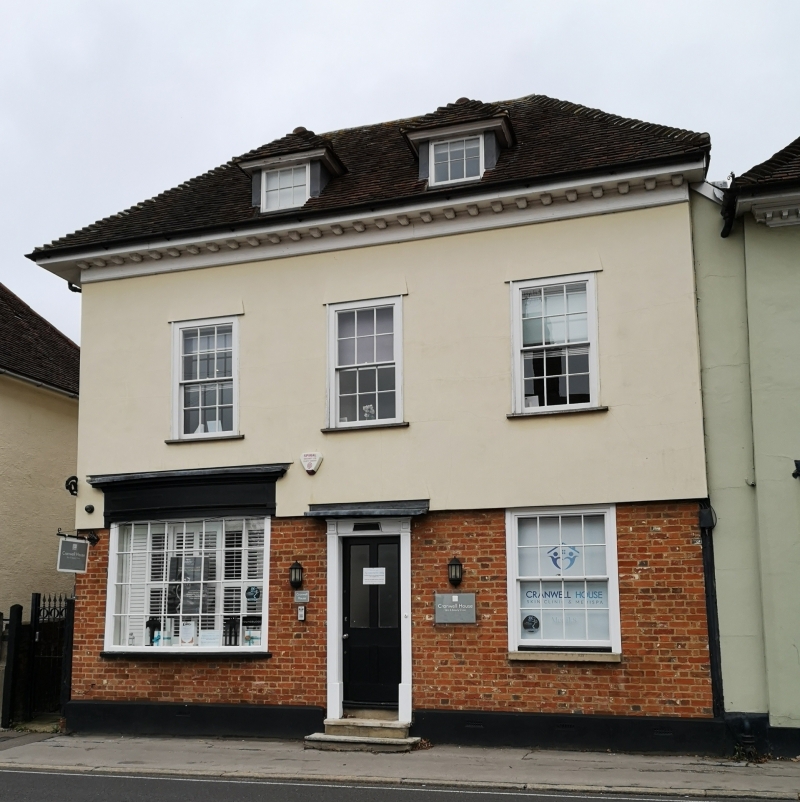
House, now offices. Late C18/early C19 altered in C19 and C20. Timber-framed, plastered, roofed with handmade red clay tiles. Main range facing SE with internal stack in rear right corner.
2 storeys and attic. Original 2-storey wing to rear right with
altered lean-to roof of shallow pitch, felted, and single-storey lean-to extension beyond. 2-storey lean-to to rear of remainder of main range, of exposed C20 brick, roofed as a catslide of the main roof. Ground floor, one bow shop window of 24 lights with fascia and moulded cornice, and simple pilaster each side, and one early C19 sash of 8+8 lights. Central 4-panel door, the lower panels flush, the
upper panels glazed, in early C19 simple doorcase with flat canopy. The front elevation has been faced with brick and plastered to the top of the doorcase, with a sloping board above; upper part of ashlared plaster. One late C19 scrolled cast-iron bracket attached to left corner of main elevation, incomplete, probably for a former lantern. Roof hipped, with one blocked hipped dormer in left pitch and C20 skylight in right pitch. The front elevation has been extended to the right to meet the adjacent house, No.100 (qv) with a slight set-back. In the left elevation is an C18 half-glazed door of 9 lights and 2 panels, with ovolo-moulded glazing bars, the lights blocked with plywood; this door is re-sited in the C20 lean-to. In the left elevation of the rear wing, on the ground floor, is an early C19 sash of 8+8 lights, and above it a similar sash of 6+6 lights.
INTERIOR: original stair from ground floor to attic with moulded handrail, stick balusters to the first floor, serpentine flat balusters to the attic. Occupied from 1841 to 1856 by the Reverend Benjamin Hayter, Minister of the Independent (Congregational) Chapel.
(Kemble JVH: Survey of Ingatestone High Street: 1987-).
Listing NGR: TQ6496199532
External links are from the relevant listing authority and, where applicable, Wikidata. Wikidata IDs may be related buildings as well as this specific building. If you want to add or update a link, you will need to do so by editing the Wikidata entry.


Other nearby listed buildings