Latitude: 53.7425 / 53°44'32"N
Longitude: -0.3195 / 0°19'10"W
OS Eastings: 510933
OS Northings: 428653
OS Grid: TA109286
Mapcode National: GBR GSP.5T
Mapcode Global: WHHGX.2649
Plus Code: 9C5XPMRJ+X6
Entry Name: Swing Bridge at Former Victoria Dock
Listing Date: 21 January 1994
Grade: II
Source: Historic England
Source ID: 1197657
English Heritage Legacy ID: 387792
ID on this website: 101197657
Location: Garrison Side, Kingston upon Hull, East Riding of Yorkshire, HU9
County: City of Kingston upon Hull
Electoral Ward/Division: Drypool
Parish: Non Civil Parish
Built-Up Area: Kingston upon Hull
Traditional County: Yorkshire
Lieutenancy Area (Ceremonial County): East Riding of Yorkshire
Church of England Parish: Hull, Drypool St Columba
Church of England Diocese: York
Tagged with: Bridge
KINGSTON UPON HULL
TA12NW SOUTH BRIDGE ROAD 680-1/9/352 Swing bridge at former Victoria Dock
II
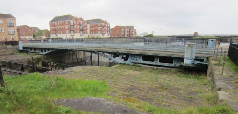
Road bridge, former railway swing bridge spanning the dock entrance. 1849. Made by Beecroft, Butler & Co., of Kirkstall Forge, Leeds, and the Haigh Foundry Co. of Wigan. Cast-iron with wrought-iron handrail and ashlar abutments. 2-leaf cantilever swing bridge with road and railway tracks. 2 strutted sections form a segmental arch when closed. Roller bearings at pivot ends. Cast-iron drums contain the gearing and hand cranks which operate the bridge by engaging with a toothed sector. Victoria Dock and the outer basin are now filled in. The half-tide basin allowed ships to enter and leave the dock at various states of the tide.
Listing NGR: TA1093328653
External links are from the relevant listing authority and, where applicable, Wikidata. Wikidata IDs may be related buildings as well as this specific building. If you want to add or update a link, you will need to do so by editing the Wikidata entry.


Other nearby listed buildings