Approximate Location Map
Large Map »
Latitude: 53.4736 / 53°28'24"N
Longitude: -2.2596 / 2°15'34"W
OS Eastings: 382867
OS Northings: 397461
OS Grid: SJ828974
Mapcode National: GBR DFK.FT
Mapcode Global: WHB9G.8Y8F
Plus Code: 9C5VFPFR+C5
Entry Name: Former Canal Flour Mills
Listing Date: 9 November 1992
Grade: II
Source: Historic England
Source ID: 1200858
English Heritage Legacy ID: 388113
ID on this website: 101200858
Location: St George's, Manchester, Greater Manchester, M15
County: Manchester
Electoral Ward/Division: City Centre
Parish: Non Civil Parish
Built-Up Area: Manchester
Traditional County: Lancashire
Lieutenancy Area (Ceremonial County): Greater Manchester
Church of England Parish: Hulme The Ascension
Church of England Diocese: Manchester
Tagged with: Building
MANCHESTER
SJ8297 EGERTON STREET
698-1/18/123 (East side)
09/11/92 Former Canal Flour Mills
GV II
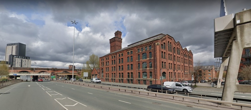
Flour mills, now warehouses, etc, and partly unoccupied at
time of survey. 1896, by William Waddington. Red brick (part
now painted), 4-span slate roof. Irregular plan within a
square, on structural axis parallel to Egerton Street, with
north end to Bridgewater Canal and integral canal basin
entered through shipping hole. Utilitarian style with
Italianate features. Four storeys over basement, plus a tower
and campanile-style chimney; with pilastered facades of 6
unequal bays to Egerton Street and 4 unequal gables at the
south end. Each bay has a Lombard frieze, the first 5 to
Egerton Street with pairs of windows and the 6th bay with 3
windows, mostly segmental-headed except for a single
round-headed opening from ground to 1st floor of the 1st bay
and all those at top floor which are square-headed and
shorter; all basement openings and most ground floor windows
now blocked. South return wall has a wide 3-bay gable with
central flat, then a 2-bay gable, and two single-bay gables,
all completely altered at ground floor but otherwise with
fenestration like that at the front except the top floor which
has stepped round-headed windows. The north end has (inter
alia) a large shipping hole; and a square sprinkler tower with
narrow 2-bay sides which have round-headed lancets and corbel
tables, a machicolated parapet (enclosing the water tank), and
a square chimney at the north east corner in similar style.
Interior (as reported by GMAU 1989): intact loading and
unloading facilities for canal boats; timber floors supported
by steel beams and cast-iron columns; disused pump in basement
for artesian well. Included as unusually complete example of
flour mill related to canal.
Listing NGR: SJ8286797461
External links are from the relevant listing authority and, where applicable, Wikidata. Wikidata IDs may be related buildings as well as this specific building. If you want to add or update a link, you will need to do so by editing the Wikidata entry.


Other nearby listed buildings
