Latitude: 51.9925 / 51°59'32"N
Longitude: -2.1566 / 2°9'23"W
OS Eastings: 389342
OS Northings: 232682
OS Grid: SO893326
Mapcode National: GBR 1JR.1KT
Mapcode Global: VH93T.K5RW
Plus Code: 9C3VXRRV+X9
Entry Name: Chapel Court
Listing Date: 4 March 1952
Grade: II
Source: Historic England
Source ID: 1201199
English Heritage Legacy ID: 376654
ID on this website: 101201199
Location: Tewkesbury, Gloucestershire, GL20
County: Gloucestershire
District: Tewkesbury
Civil Parish: Tewkesbury
Built-Up Area: Tewkesbury
Traditional County: Gloucestershire
Lieutenancy Area (Ceremonial County): Gloucestershire
Church of England Parish: Tewkesbury St Mary the Virgin (Tewkesbury Abbey)
Church of England Diocese: Gloucester
Tagged with: Chapel
TEWKESBURY
SO8932 BARTON STREET 859-1/6/68 (South side) 04/03/52 Nos.78, 79, AND 80 Chapel Court
GV II
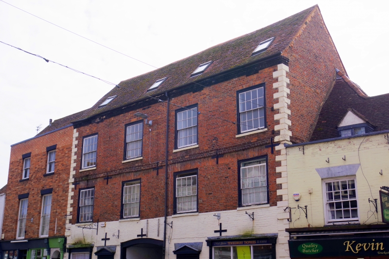
Block of apartments, formerly the Star and Garter Inn. Dated 1715 on a rainwater head, with C19 fenestration. Flemish bond brickwork, partly timber-framed, tile roof. PLAN: A large property with wide central carriageway to a courtyard, wings each side. EXTERIOR: 3 storeys, attic and basement, 4-windowed. C20 lay-lights to roof, 16-pane sashes to brick voussoirs and stone cills at first and second floors, and at ground floor, in painted brickwork, a plate-glass square C19 pilaster shop front and a C20 glazed door in pedimented surround to the left, and a similar pedimented door and doorcase with 3-pane C19 shop front to the right. Between these is a wide opening to a cambered head, with C20 wrought-iron gates set to heavy door framing. There are alternating V-joint painted quoins each end, plain brick string above first floor, and brick dentil eaves. No stack is visible. The wide sash windows appear to have been set into openings formerly filled by narrower C18 windows, and the first floor originally had 5 or 7 bays, alternate bays having been blocked, but the voussoirs remain. To each side of the carriageway are plain brick walls, with a door to flats Nos 2-5 on the right. The back wall of the street block has a broad gable in brick, with large plate-glass sashes to concrete lintels. To the right of the carriage opening is a square lead downpipe, with a tripartite hopper-head carrying the 1715 date. Beyond this is a lower 2-storey wing, which continues, enclosing the courtyard, to a timber-framed end wall and return range. The wing to the W, in 2 floors, has a door flanked by tripartite sashes at ground floor, and above, built in to the walling, a good C18 or early C19 wood balustrade. On the E side, beyond the wing, is a small gabled cottage, now (January 1992) commercial premises. INTERIOR not inspected, but remodelled as apartments. This was an important inn in the town, but already closed by 1774. The modification to the street front, in which C18 sashes were either blocked, or replaced by wider 16-pane sashes in the early C19, is hard to explain; the result is an uncomfortable spacing of windows, with the outer sashes too close to the ends of the front. The property extended the full depth of the plot, to Swilgate Street at the rear, but later a Baptist Chapel was built near the rear of the site (now transformed into dwellings).
Listing NGR: SO8934232681
External links are from the relevant listing authority and, where applicable, Wikidata. Wikidata IDs may be related buildings as well as this specific building. If you want to add or update a link, you will need to do so by editing the Wikidata entry.


Other nearby listed buildings