Approximate Location Map
Large Map »
Latitude: 53.5409 / 53°32'27"N
Longitude: -2.7205 / 2°43'13"W
OS Eastings: 352352
OS Northings: 405162
OS Grid: SD523051
Mapcode National: GBR 9WFH.TD
Mapcode Global: WH86S.58T9
Plus Code: 9C5VG7RH+9R
Entry Name: The Owl Inn
Listing Date: 25 June 1973
Grade: II
Source: Historic England
Source ID: 1201608
English Heritage Legacy ID: 389067
Also known as: Owl Inn
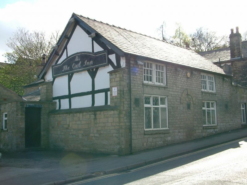
The Owl Inn, Skelmersdale
ID on this website: 101201608
Location: Up Holland, West Lancashire, WN8
County: Lancashire
District: West Lancashire
Civil Parish: Up Holland
Built-Up Area: Wigan
Traditional County: Lancashire
Lieutenancy Area (Ceremonial County): Lancashire
Church of England Parish: Up Holland St Thomas
Church of England Diocese: Liverpool
UP HOLLAND
SD5205 SCHOOL LANE
783-1/7/76 (South West side)
25/06/73 No.47
The Owl Inn
GV II
Public house. Probably earlier C17, but remodelled, altered
and enlarged. Remains of timber-framing in east gable wall,
but otherwise coursed squared sandstone rubble, with slate
roofs. Irregular plan composed of former 2-unit main range
with rear wing, additions to the rear and at the right-hand
end, 2 low storeys; 2 windows; a blocked round-headed doorway
offset left of centre, with dressed voussoirs and raised
keystone; enlarged square windows at ground floor with raised
sills and wedge lintels, and transomed 3-light casements; 2
pairs of small coupled 9-pane sashed windows at 1st floor. The
left gable wall has rendered cladding at ground floor, but
above that the original timber-framing is exposed, with corner
posts, 2 intermediate posts, one rail, angle-braces in the
upper panels, and a principal-rafter roof truss with vertical
struts to the principals. At the right-hand end is a
single-storey continuation. INTERIOR: remodelled, but the 2nd
bay has 2 large quarter-round moulded lateral beams and a
chamfered beam at the junction with the rear wing; and the 1st
bay has a similar stop-chamfered lateral beam terminating at a
C20 beam which has replaced a former longitudinal partition.
Listing NGR: SD5235205162
External links are from the relevant listing authority and, where applicable, Wikidata. Wikidata IDs may be related buildings as well as this specific building. If you want to add or update a link, you will need to do so by editing the Wikidata entry.


Other nearby listed buildings
