Latitude: 54.5398 / 54°32'23"N
Longitude: -1.9233 / 1°55'23"W
OS Eastings: 405061
OS Northings: 516062
OS Grid: NZ050160
Mapcode National: GBR HH0Y.DD
Mapcode Global: WHB4L.F5D1
Plus Code: 9C6WG3QG+WM
Entry Name: Garden Walls to Number 8 Garden Walls to Thorngate House
Listing Date: 22 February 1973
Last Amended: 28 November 1994
Grade: II
Source: Historic England
Source ID: 1201691
English Heritage Legacy ID: 388839
ID on this website: 101201691
Location: Startforth, County Durham, DL12
County: County Durham
Civil Parish: Barnard Castle
Built-Up Area: Barnard Castle
Traditional County: Durham
Lieutenancy Area (Ceremonial County): County Durham
Church of England Parish: Barnard Castle with Whorlton
Church of England Diocese: Durham
Tagged with: Wall
BARNARD CASTLE
NZ0516SW THORNGATE 770-1/6/212 (East side) 22/02/73 Garden walls to No.8 (Formerly Listed as: THORNGATE Rear and Return garden wall and gateway of Nos.8 & 8A)
GV II
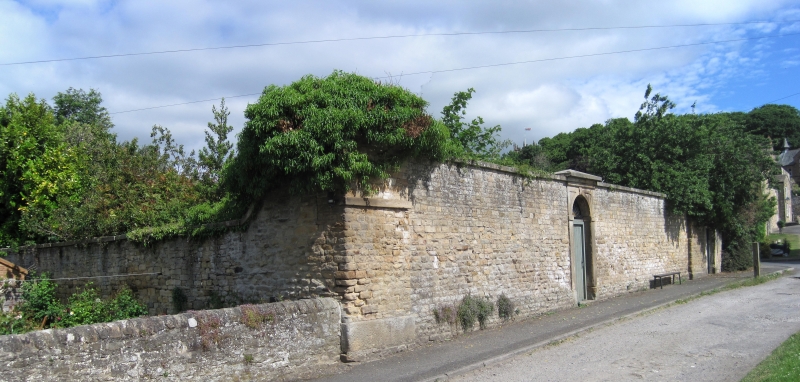
Garden walls to No.8 Thorngate (qv). Mid C18. Rubble with stone coping. High garden walls enclose rear garden of No.8 Thorngate, breaking forward from rear of building, continuing around rear of property at Nos 2, 4 & 6 Thorngate, and join rear wall of No.2 (qv) to continue along the south side of Gray Lane. From east end of Gray Lane they join River View (qv) and form south side of that garden, returning to form boundary with the Demesnes and returning west again to rejoin the rear of No.8 Thorngate. The east length facing the Demesnes has wide square corner piers with low pyramidal coping, and near-central keyed round-arched gateway with boarded gate recessed in similar pier. Included for group value.
Listing NGR: NZ0506116062
External links are from the relevant listing authority and, where applicable, Wikidata. Wikidata IDs may be related buildings as well as this specific building. If you want to add or update a link, you will need to do so by editing the Wikidata entry.
Other nearby listed buildings