Approximate Location Map
Large Map »
Latitude: 52.5958 / 52°35'44"N
Longitude: -2.1044 / 2°6'15"W
OS Eastings: 393026
OS Northings: 299785
OS Grid: SO930997
Mapcode National: GBR 1KF.HV
Mapcode Global: WHBFZ.N03T
Plus Code: 9C4VHVWW+86
Entry Name: Holy Trinity Almshouses to West of Church of Holy Trinity
Listing Date: 3 February 1977
Last Amended: 31 March 1992
Grade: II
Source: Historic England
Source ID: 1201798
English Heritage Legacy ID: 378371
ID on this website: 101201798
Location: Park Village, Wolverhampton, West Midlands, WV10
County: City of Wolverhampton
Electoral Ward/Division: Heath Town
Parish: Non Civil Parish
Built-Up Area: Wolverhampton
Traditional County: Staffordshire
Lieutenancy Area (Ceremonial County): West Midlands
Church of England Parish: Heath Town Holy Trinity
Church of England Diocese: Lichfield
Tagged with: Almshouse
WOLVERHAMPTON
SO99NW CHURCH STREET, Heathtown
895-1/5/71 (West side (off))
03/02/77 Holy Trinity Almshouses to W of
Church of Holy Trinity
(Formerly Listed as:
STATION ROAD, Heath Town
Holy Trinity Almshouses)
GV II
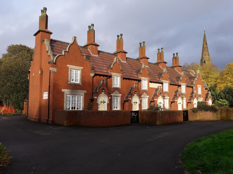
Terrace of 6 almshouses. c1850. For Henry Rogers. Roughcast
brick with tile roof and roughcast stacks. Jacobean style.
Single storey with attic; 6-window range; ends break forward
under shaped gables with kneelers, upper parts missing at time
of resurvey (1990). Windows have dripstones and are blocked
(1990), recorded as having casements; upper windows under
shaped gables; entrances between windows and to right end have
elliptical heads in slightly projecting porches with shaped
gables, recessed doors blocked (1990), recorded as having
enriched wrought-iron strap hinges. Panel in centre under
eaves has worn inscription, recorded as: GIVE GOD THE GLORY.
Coped gables, that to right return shaped; truncated end stack
to left, 5 cross-axial stacks with diagonal shafts, caps
missing. Rear has ends breaking forward under shaped gables;
paired blocked entrances; ends of projecting walls. Derelict
at time of resurvey.
Listing NGR: SO9302699785
External links are from the relevant listing authority and, where applicable, Wikidata. Wikidata IDs may be related buildings as well as this specific building. If you want to add or update a link, you will need to do so by editing the Wikidata entry.


Other nearby listed buildings
