Approximate Location Map
Large Map »
Latitude: 50.4547 / 50°27'16"N
Longitude: -4.4615 / 4°27'41"W
OS Eastings: 225362
OS Northings: 64542
OS Grid: SX253645
Mapcode National: GBR NF.NRV1
Mapcode Global: FRA 17JV.KPG
Plus Code: 9C2QFG3Q+VC
Entry Name: 12, Castle Street
Listing Date: 15 November 1993
Grade: II
Source: Historic England
Source ID: 1203157
English Heritage Legacy ID: 382136
ID on this website: 101203157
Location: Liskeard, Cornwall, PL14
County: Cornwall
Civil Parish: Liskeard
Built-Up Area: Liskeard
Traditional County: Cornwall
Lieutenancy Area (Ceremonial County): Cornwall
Church of England Parish: Liskeard
Church of England Diocese: Truro
Tagged with: Building
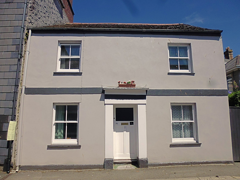
LISKEARD
SX2564 CASTLE STREET
979-1/5/44 (East side)
No.12
GV II
Town house. Early C19. Rendered rubble walls; asbestos slate
roof. Double-depth plan. 2 storeys; symmetrical 2-window
front. C20 four-pane horned sashes; central doorway with
wooden doorcase with flat pilasters and simple entablature;
C20 door. INTERIOR not inspected. Included for group value.
Listing NGR: SX2536264542
External links are from the relevant listing authority and, where applicable, Wikidata. Wikidata IDs may be related buildings as well as this specific building. If you want to add or update a link, you will need to do so by editing the Wikidata entry.


Other nearby listed buildings
