Latitude: 51.3336 / 51°20'1"N
Longitude: 1.4031 / 1°24'11"E
OS Eastings: 637148
OS Northings: 164891
OS Grid: TR371648
Mapcode National: GBR X0L.7K6
Mapcode Global: VHMCW.8RL0
Plus Code: 9F338CM3+C6
Entry Name: Water Tower of Ramsgate Water Works Including Area Railings, Gate Piers to West
Listing Date: 4 February 1988
Last Amended: 17 October 1988
Grade: II
Source: Historic England
Source ID: 1203415
English Heritage Legacy ID: 172010
ID on this website: 101203415
Location: Nethercourt, Thanet, Kent, CT11
County: Kent
District: Thanet
Civil Parish: Ramsgate
Built-Up Area: Ramsgate
Traditional County: Kent
Lieutenancy Area (Ceremonial County): Kent
Tagged with: Water tower
In the entry for RAMSGATE SOUTHWOOD ROAD (east side) Water Tower of Ramsgate Water Works
The address, grade and description shall be amended to read
TR 3764 NW Ramsgate SOUTHWOOD ROAD (east side) 11/374 Water Tower of Ramsgate Water Works including area railings, gate-piers to west GV II
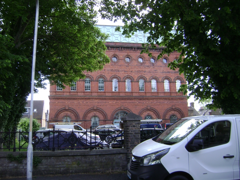
Water towe. Erected 1881, Stevenson + Valon, engineers. Red brick and terracotta with cast iron water tank 80 feet by 50, 60 feet high. Corrugated aspestos roof. Three storeys with tank on top. Five bay arcaded base, with moulded cornice to lst floor, and a paired modillion eaves cornice. Two stage tank with octagonal pattern rib-bracing. Ten bull's-eyes to 2nd floor, keyed, with brick band joining them, with moulded aprons below. Ten round headed cast-iron casements on 1st floor, keyed and moulded heads with cornice and cill bands, and raised aprons below. Ground floor arcading with moulded double order of keyed semi-circular arches, and keyed cast-iron casements. Central double boarded doors with semi-circular cast-iron fanlight. Plagues to left of door: Ramsgate Water Works This Tower and Reservoir erected 1887 Stevenson & Valon, Engineers. (et al.). The plaque to right bears the town shield and is inscribed Ramsgate Improvement Commission. Rear elevation identical but central doorway 3 bay return elevations.
Interior is divided into 5 bays by axial walls each with 3 arches on the ground and first floors. The water tank is supported on closely-spaced iron girders and covered by a roof with trusses in the form of lattice braced girders. There is a hoist well through the floors at the centre and the original staircase is against the rear wall. The pump to fill the can is now situated outside the building but originally might have been inside in the north west corner. The tank holdss 250,000 gallons.
Including front area wall, railings, gate-piers and gates to west. Circa 1881. Low stock birch wall and piers with rendered coping surmounted by arnate cast-iron railings with twisted standards. The gateway of the centre has a pair of octagonal cast iron gate-piers with moulded caps and double gates of similar design to the railings.
Source Busson, Ramsgate, 38
------------------------------------------------------------------- RAMSGATE SOUTHWOOD ROAD TR 3764 NW (east side) 11/374 Water Tower of Ramsgate Water Works GV II*
Water tower. Erected 1881, Stevenson + Valon, engineers. Red brick and terracotta with cast iron water tank 80 feet by 50, 60 feet high. Three storeys with tank on top. Five bay arcaded base, with moulded cornice to 1st floor, and paired medallion eaves cornice. Two stage tank with octagonal pattern rib-bracing. Ten roundels to 2nd floor, keyed, with brick band joining them, with moulded aprons below. Ten round headed metal casements on 1st floor, keyed and moulded heads with cornice and cill bands, and raised and fielded aprons below. Ground floor arcading with double rebate and moulded and keyed semi-circular heads, and keyed metal casements. Central double boarded doors with semi-circular metal fanlight. Plaques to left of door: Ramsgate Water Works This Tower and Reservoir erected 1887 Stevenson & Valon, Engineers. (et al.).
The plaque to right bears the town shield. Rear elevation identical with 3 bay return elevations. The water tank holds 250,000 gallons. Some internal machinery reported still. (Busson, Ramsgate, 38 ).
Listing NGR: TR3714864891
External links are from the relevant listing authority and, where applicable, Wikidata. Wikidata IDs may be related buildings as well as this specific building. If you want to add or update a link, you will need to do so by editing the Wikidata entry.


Other nearby listed buildings