Approximate Location Map
Large Map »
Latitude: 50.552 / 50°33'7"N
Longitude: -2.4255 / 2°25'31"W
OS Eastings: 369954
OS Northings: 72555
OS Grid: SY699725
Mapcode National: GBR PZ.3C3T
Mapcode Global: FRA 57TL.T1R
Plus Code: 9C2VHH2F+QR
Entry Name: Grove County Primary School with Rear Boundary Wall
Listing Date: 21 September 1978
Last Amended: 17 May 1993
Grade: II*
Source: Historic England
Source ID: 1205631
English Heritage Legacy ID: 381958
ID on this website: 101205631
Location: Grove, Dorset, DT5
County: Dorset
Civil Parish: Portland
Built-Up Area: Grove
Traditional County: Dorset
Lieutenancy Area (Ceremonial County): Dorset
Church of England Parish: Portland All Saints
Church of England Diocese: Salisbury
Tagged with: Architectural structure
PORTLAND
SY67SE GROVE ROAD, Grove
969-1/1/137 (North East side)
21/09/78 Grove County Primary School with
rear boundary wall
(Formerly Listed as:
GROVE ROAD, Grove
(North East side)
Grove County Infant School)
GV II*
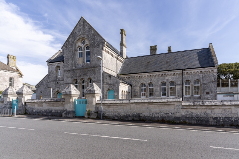
School. Opened September 2nd 1872. Probably from the office of
Capt. Edmund du Cane, RE, designer of St. Peter's Church (qv).
Portland ashlar, slate roofs. A richly detailed and
confidently handled Romanesque Revival building with a
cruciform plan. Lofty 2-storey gabled units to N,E and W, and
a lower single-storey hall unit to the S (right). A boys'
entrance to the left and girls' to the right gave access to a
long, narrow, full-depth hall on two floors, with the infants'
hall to the right. In the re-entrant angles are single-storey
units, with a further extension of 1898 to the left, partly
rebuilt in the late C20.
Exterior has round-arched windows set to single or paired
shafts and responds; in the high gables are paired lights
under an oculus with a sunk panel within the containing arch.
Steeply-pitched roofs have coped gables, and small-scale
Lombard bands at the eaves, concealing ventilation openings to
the halls. One large and 2 smaller heavily modelled eaves
stacks. A complex fenestration includes groups of 3 lights to
an outer shafted screen under the 3 main gables, and 3 paired
lights similarly to the lower hall. The lean-to entrance lobby
has 4 simpler arched windows. Deep glacis-like sloping cills,
various string and lintel bands. To the left of main gable to
street is a plank door in arched entry; the corresponding
entry to the right is now (1991) blocked.
Interior: a stone open-well cantilevered stair in the
left-hand lobby gives access to the boys' hall at first floor;
simply detailed, with iron handrail and alternate twisted iron
balusters. Upper hall has a 5-bay arch-braced roof, lower hall
has moulded cornice. Off the left-hand side of each hall is a
large classroom in the N wing, and to the right at ground
floor the long former infants' hall. This has a series of
sealed ventilators at eaves level each side, and a large
classroom opens off to the left.
Subsidiary Features: a lofty stone wall divides the playground
at the rear of the building, and there are substantial remains
of the former privy blocks set back against the outer boundary
wall. The boundary walls to The Grove (qv) are also important
to the setting of the School. The School log books and
punishment book are retained, also an architect's development
drawing (unsigned) in pencil, dated 22/06/63. This is a
precious document, which shows an earlier version of the
building with 3 lofty dormers to the infants' wing. The log
book records for September 2nd 1872 include: "This day we
opened the new School, 71 in attendance. Addresses were made
..... Rev. G. Taylor exhorting the boys to perseverance,
diligence, and to careful attention to the School's ordinary
work ....." Edward W. Moore was at that time the Master. The
building is a very lively and carefully articulated design,
little altered within, and, with the supporting documents, an
important survival of C19 social history. It forms part of a
major group of buildings - developed as a result of the
establishment of the prison here (established 1848) -
comprising Church, Vicarage, School House, School, and Alma
Terrace (qqv).
Listing NGR: SY6995472555
External links are from the relevant listing authority and, where applicable, Wikidata. Wikidata IDs may be related buildings as well as this specific building. If you want to add or update a link, you will need to do so by editing the Wikidata entry.


Other nearby listed buildings
