Latitude: 50.5709 / 50°34'15"N
Longitude: -2.4171 / 2°25'1"W
OS Eastings: 370559
OS Northings: 74659
OS Grid: SY705746
Mapcode National: GBR PZ.N1C5
Mapcode Global: FRA 57TK.B5D
Plus Code: 9C2VHHCM+95
Entry Name: The inner and outer breakwater, including the coaling shed, storehouse jetty, coaling jetty, inner breakwater fort and outer breakwater fort
Listing Date: 21 September 1978
Last Amended: 26 February 2018
Grade: II
Source: Historic England
Source ID: 1205991
English Heritage Legacy ID: 382004
ID on this website: 101205991
Location: Portland Harbour, Dorset, DT5
County: Dorset
Civil Parish: Portland
Lieutenancy Area (Ceremonial County): Dorset
Tagged with: Architectural structure Building complex
The inner and outer breakwater, including the coaling shed, storehouse jetty, coaling jetty, inner breakwater fort and outer breakwater fort. Constructed between 1849 and 1882. Designed by Chief Engineer, James Meadow Rendel, succeeded by John Coode in 1856, and carried out by civil engineer John Towlerton Leather. The outer breakwater fort was designed by Captain E H Steward. Late C19, C20 and C21 alterations and additions. All post-1945 buildings, structures and plant added to the structures are excluded from the listing.
The inner and outer breakwater, including the coaling shed, storehouse jetty, coaling jetty, inner breakwater fort and outer breakwater fort. Constructed between 1849 and 1882. Designed by Chief Engineer, James Meadow Rendel, succeeded by John Coode in 1856, and carried out by civil engineer John Towlerton Leather. The outer breakwater fort was designed by Captain E H Steward. Late C19, C20 and C21 alterations and additions. All post-1945 buildings, structures and plant added to the structures are excluded from the listing.
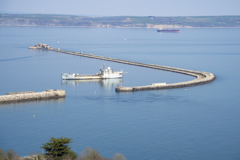
PLAN: the inner breakwater, inclusive of the storehouse jetty which forms the return to the west into The Camber, and the inner breakwater fort at the outer (north-east) end, is a total length of approximately 750m. Separated by the South Ship Channel, the outer breakwater forms a continuation of the inner breakwater and runs from south to north, curving towards the west at its southern end. At the northern end is the outer breakwater fort, and extending to the south-west is the L-shaped jetty. The outer breakwater has a total length of approximately 1820m.
DESCRIPTION
The STOREHOUSE JETTY at the western extent of the inner breakwater is constructed of large, bolstered roach stone blocks to a battered face. The west end has been rebuilt (1906). There are some of the timber stubs of the mid-C19 coaling stages to either side.
The COALING SHED is constructed of Portland rubble stone with ashlar dressings, and originally had a slate roof; it is now corrugated iron. It is a long 11-bay stone structure arranged in two parallel ranges with gabled west and east ends; the east gable has been rebuilt in brick above the eaves line. The roof is divided by two raised and coped 'party divisions' which do not correspond with the main bay articulation. The south elevation has eleven sunken panels, divided by a high band, and a series of segmental-headed openings near ground level, and four larger openings in bays 3, 4, 6 and 8. At the right-hand end is a single-storey, breeze-block addition. The north elevation is as the south, with the addition of two staircases to the upper doors. The west gable has a pair of large lunette windows, beneath which are the timber stubs of the platform used to transfer coal to the shed. Both the west and east end have three, ground-floor arched openings with keystones; the central arch is wider than the outer two and corresponds to the layout of the internal tunnels.
The ground floor of the coaling shed has a main axial brick-vaulted tunnel with stone surrounds to segmental-arched openings leading into the narrower side tunnels. The upper floor of the coaling shed, originally a coal store, is divided longitudinally by raised baulks and heavy axial timbers with braces supporting a double king post roof with joists in iron shoes. The rails for the former coal wagons and other original parts of the coaling system also remain. The lube oil storage tanks to the eastern end of the coaling shed and the alterations to provide office accommodation are not of special interest and excluded from the listing.
The INNER BREAKWATER continues towards the east, and its stone construction has large bolstered stone blocks to a battered seaward face. The upper, elevated section is the Prince Consort Walk and at its western end is a carved commemorative stone. On its west face is the Royal Coat of Arms and on the north face is the inscription:
FROM THIS SPOT / ON THE 25TH JULY 1849 / HIS ROYAL HIGHNESS PRINCE ALBERT, / CONSORT OF QUEEN VICTORIA / SUNK THE FIRST STONE OF THIS BREAKWATER. / UPON THE SAME SPOT / ALBERT EDWARD, PRINCE OF WALES, / ON THE 18TH AUGUST 1872 / LAID THIS LAST STONE / AND DECLARED THE WORK COMPLETE. / THESE ARE THE IMPERIAL WORKS / AND WORTHY (OF) KINGS.
The east face is inscribed:
JAMES MEADOW RENDEL / DESIGNED THIS WORK / AND DIRECTED ITS EXECUTION / TILL HIS DEATH IN 1856. / JOHN COODE, / THE RESIDENT ENGINEER FROM ITS COMMENCEMENT, / THEN SUCCEEDED TO ITS CHARGE / AND COMPLETED IT. / J.T. LEATHER WAS THE / CONTRACTOR FOR THE WORK.
The inner face of the breakwater has brick-vaulted, stone storage chambers with segmental arched openings with keystones. The chambers are divided by battered piers. Some of the openings have been walled across with brick or concrete, and some have had modern plant inserted, these later alterations are not of interest and excluded from the listing. Above is a stone cornice, and projecting from and beneath the cornice are the timber stubs of the staging that supported the hydraulic chute system to the COALING JETTY where coal was transferred to the ships. The inner walkway is paved with stone setts; although the inner section is now covered with tarmac.
The INNER BREAKWATER FORT is built of roach stone and granite. The circular fort has a diameter of 35m and is accessed from the breakwater via a stone staircase and wooden bridge, replacing an earlier sliding bridge. To either side of the drawbridge are flanking walls with granite cones projecting from the coping stones. A segmental arched opening, partially infilled with brick, gives access to the gun floor that retains the shell and cartridge hoists from 1897, the mountings for the quick-firers, and the concrete glacis, a sloping surface, to its southern side. A plaque has been added to the gun floor inscribed:
THIS STONE COMMEMORATES THE VISIT BY / HIS ROYAL HIGHNESS / THE PRINCE PHILIP DUKE OF EDINBURGH / ON 14TH JULY 1999 / TO CELEBRATE THE 150TH ANNIVERSARY OF / THE LAYING OF THE FIRST STONE OF / THE PORTLAND BREAKWATERS / BY / THE PRINCE ALBERT THE PRINCE CONSORT
To the centre of the gun floor is an iron cover which provides access to the magazine below. The magazine has a cross plan with a stone spiral staircase within a brick stairwell to its centre. The southern arm has been filled with concrete as has part of the eastern arm but it retains cartridge and shell stores.
The OUTER BREAKWATER similarly consists of an inner pier and an elevated section on the seaward side. It is built of large boulders, and the outer face is sloped towards the sea and is mortared in places. The inner face of the elevated section is largely of cut, and coursed stone, with some sections of strewn boulders. There is evidence of repair and rebuilding along its length. On the elevated section survive some of the timber piles for the original staging for the rails, and there are baulks of timbers. The circular pierhead at the south end is faced in granite and has a Second World War concrete searchlight, as well as the winches and bollards associated with working the boom that closes the South Ship Channel. Behind the pierhead is a small landing stage, and a ramp along the inner face of the breakwater. There are the ruins of an unroofed, ashlar building. Further towards the north are C20 searchlights and observation posts. And at the northern end, which terminates with the outer breakwater fort, are a series of C19 and C20 buildings of brick, stone and concrete which includes a single-storey, four-bay building of rusticated stone with ashlar to the openings, and internally, a fireplace and niches. To the inner face of the outer breakwater, at the northern end, is a triangular landing platform.
The OUTER BREAKWATER FORT is constructed on a concrete substructure that is faced in granite. Above is the cast iron fort which comprises two rings of iron box-girders, supplied by Jeavons & Co. of Millwall, fanning from a central, octagonal well. The walls are three thicknesses of 15cm iron plates, supplied by Messrs Brown of Sheffield. The iron roof is capped with concrete, and on top of the roof is a Second World War pre-cast concrete coastal artillery searchlight.
Internally, the central well is faced with ashlar with rusticated Roach stone forming the quoins and keystones to the arched openings to the gun rooms and ports for fourteen guns. There is concave fluting to the sloping ceiling to the gunports, supported by pillars between the casements. The lower level has shell and cartridge stores and separate passages and lifts for both. To the centre is the former engine room. Both levels of the fort are connected by a spiral cast-iron staircase. The fort retains many fixtures and fittings including doors, slatted timber floors to guard against explosions, pegs for hanging clothes changed when ammunition was being handled, and an original lamp in the lamp passage, as well as shell hoists.
The buildings to either side of the ramp leading from the west entrance of the fort to the L-shaped jetty, are early-C20 garrison buildings. The ramp leads down to a two-tier structure. On the upper floor is a late C19 gun emplacement with associated magazine stores and a C20 concrete-rendered brick building added to the ground floor of an earlier stone building. To the lower floor are three segmental arched openings, behind which are stores and ablutions. The position of the capstan and winch which transferred the guns onto rails up the slow-rising staircase and ramp to the right, is evident in grooves to the side of the jetty. The jetty continues to the west over three segmental arches with quoins and keystones. Above is a flat-roofed, altered, brick building and a three-bay, flat-roofed stone building with rusticated quoins to the openings. To the rear wall of the jetty are the winches for the boom. The jetty continues to the south.
Pursuant to s1 (5A) of the Planning (Listed Buildings and Conservation Areas) Act 1990 (‘the Act’) it is declared that all post-1945 buildings, structures and plant added to the inner and outer breakwater, the coaling shed, storehouse jetty, coaling jetty, inner breakwater fort and outer breakwater fort are not of special architectural or historic interest. These include:
the small brick lean-to attached to the east end of the coaling shed;
the oiling jetty, attached to the storehouse jetty;
the detached late-C20 building with corrugated iron roof to the east of the coaling shed;
the brick and concrete walling across the openings of some of the storage chambers and the inserted modern plant;
the fuelling jetty and associated pipelines;
the mid-C20 building, known as the salvage shed, attached to the inner face of the inner breakwater, at its eastern extent.
The area around Portland Harbour has historically been recognised as an important military strategic location. The advent of a steam-driven naval fleet in the early to mid-C19 necessitated the storage of large quantities of coal, not only at the dockyards, but also at strategic locations determined by the likelihood of enemy attack and the limited range of the steamship when using its engines alone. Portland, conveniently situated equidistant between Portsmouth and Plymouth and facing the French naval dockyard at Cherbourg, was established as the first naval anchorage specifically designed for the navy’s fleet of steam-driven warships, and the necessary breakwaters and coaling facilities were an integral part of the scheme. Suggestions for fortifying the anchorage here were first put forward in 1835. An 1844 survey map of Portland, by surveyor John Taperell, shows the proposed breakwater structures of the scheme designed by the Admiralty’s Chief Engineer, James Meadow Rendel. Preliminary works for the breakwaters began in 1847 with the formal construction of the inner breakwater being marked by a ceremony in which HRH Prince Albert laid the foundation stone on 25 July 1849.
The inner and outer breakwater were intended to be straight, but after work began John Coode, Resident Engineer (who succeeded Rendel as the Admiralty’s Chief Engineer in 1856) suggested that the outer arm be curved. This was considered as a great improvement by Rendel and the plan of the breakwaters drawn up in 1852 incorporates this amendment. Both breakwaters were constructed from stone brought from the quarries on Portland via an inclined railway and using timber piers, railways and cranes, stone was dumped into the sea from a height and the action of the sea compacted the mass. The breakwaters were very successful, being cheap to construct and effective in providing a harbour of refuge for the ships using the coaling facility.
The coaling shed (1856-1860) at the western extent of the inner breakwater and the coaling jetty halfway along the breakwater’s length operated to replenish the navy’s steam fleet. Coal was lifted from colliers berthed at the west end of the storehouse jetty, via hydraulic cranes, into wagons which ran on four sets of rails in the roof of the coaling shed. The coal was then either stored at first-floor level or transferred to the ground floor tunnels from where the wagons carried the coal, via the viaduct, onto the elevated section of the inner breakwater, the Prince Consort Walk, and the coal was transferred to the vessels by hydraulic chutes to ships at the coaling jetty. The coaling operation was regarded as a failure and adaptations were made. By 1869 coal was being unloaded in bags from the sides of the coaling shed by manually-operated winches and berthed at three, timber coaling stages which had been built on either side of the jetty. Lighters would carry the coal out to the ships. These have since been removed and the system was condemned in 1885. The west end of the storehouse jetty was rebuilt in 1906. In 1907 the viaduct, which had carried the rails from the coaling shed to the inner breakwater, was demolished and replaced with a new viaduct with concrete arches faced in ashlar. Four of these seven arches have now (2017) been demolished.
In 1859, due to concerns over a possible French invasion, Lord Palmerston, the Prime Minister, instigated the establishment of the Royal Commission on the Defence of the United Kingdom which recommended that vital points along the south coast, including the Royal Dockyards at Portsmouth, Chatham, Plymouth and Portland, be fortified. As a consequence the defences at the port were developed and large scale construction work took place in and around Portland Harbour from 1862, when the Admiralty handed over the site to the war office. This included the advancement of the 1840s scheme to build defensive breakwaters.
The inner breakwater fort, a coastal artillery battery at the north-east end of the inner breakwater, was designed by the Admiralty in 1859 and constructed by local builders Jesty and Baker between 1859 and 1862. The war office completed the fort in 1866. The armament rapidly became obsolete due to military advances and between 1897 and 1899 the fort was upgraded and the five north-eastern chambers of the inner breakwater were adapted to provide accommodation and a cookhouse, and latrines were added. In 1902 a concrete glacis, a sloping structure, was added to the seaward side of the fort incorporating positions for two 12-pounder quick-firers and a Maxim gun as part of its anti-torpedo defences. These were removed by 1919 and it was rearmed with 6” and 9.2” breech loading guns. During the Second World War it was equipped with a 40mm Bofors gun.
The outer breakwater fort was added to the north end of the outer breakwater in 1869-1882. It was originally designed by Captain E H Steward in 1857 as a casemented granite structure, but it was amended to a single-tier stone and iron fort armed with fourteen, 12.5 rifled muzzle-loading guns, installed between 1874 and 1875. To install the guns the L-shaped jetty was added to the breakwater, extending from the fort’s entrance, and including rails to transfer the guns to the fort. The guns themselves were powered, supplied with ammunition, and operated, using a steam engine that was installed at the fort in 1884. In 1900 the gun floor was altered for the installation of two, 12-pounder quick-firer guns, which were also installed on the jetty. In 1907 the fort’s armament was replaced and the remaining rifle muzzle-loading guns were broken up and discarded; some of the remains are evident on the seaward side of the outer breakwater.
There are a number of additional buildings added around the outer breakwater fort and to the jetty, as well as the northern end of the breakwater. The rendered brick buildings largely date from the First World War, and the breeze block, concrete and steel constructions from the breakwater’s re-use during the Second World War. A plan of 1947 shows the function of each of these buildings. By 1956 the fort was abandoned as a coastal defence, and the breakwater as a coastal watch.
The inner and outer breakwater, including the coaling shed, storehouse jetty, coaling jetty, inner breakwater fort and outer breakwater fort are listed at Grade II for the following principal reasons:
Architectural interest:
* The huge and impressive engineering feat of constructing the breakwaters;
* An innovative combination of Victorian architecture and hydraulic engineering in response to the problems of coaling the increasingly steam-driven navy of the time;
* Association with nationally significant engineers, J M Rendel, J Coode and E H Seward;
* The good degree of survival.
Historic interest:
* As the first safe anchorage specifically designed to create a harbour of refuge to replenish the navy’s fleet of steam-driven warships;
* The importance of the mid-C19 coaling shed in the history of the mechanised fuelling of ships;
* Fortification of the breakwaters in response to the 1859 Royal Commission on the Defence of the United Kingdom, a nationally important period of England’s military history;
* Subsequent adaptation to the fortifications to keep pace with advancing military tactics and technology.
Group value:
* As part of a largely complete naval base of considerable importance;
* With the Grade II listed late C19 Bincleaves Groyne and North-Eastern Breakwater to the north of the harbour.
External links are from the relevant listing authority and, where applicable, Wikidata. Wikidata IDs may be related buildings as well as this specific building. If you want to add or update a link, you will need to do so by editing the Wikidata entry.


Other nearby listed buildings