Approximate Location Map
Large Map »
Latitude: 50.5654 / 50°33'55"N
Longitude: -2.4328 / 2°25'57"W
OS Eastings: 369444
OS Northings: 74052
OS Grid: SY694740
Mapcode National: GBR PZ.2H3C
Mapcode Global: FRA 57SK.XQ3
Plus Code: 9C2VHH88+5V
Entry Name: East Weare Batteries at Sy 694 741
Listing Date: 17 May 1993
Grade: II
Source: Historic England
Source ID: 1281863
English Heritage Legacy ID: 381980
ID on this website: 101281863
Location: Portland Port, Dorset, DT5
County: Dorset
Civil Parish: Portland
Traditional County: Dorset
Lieutenancy Area (Ceremonial County): Dorset
Church of England Parish: Portland All Saints
Church of England Diocese: Salisbury
Tagged with: Architectural structure Artillery battery
PORTLAND
SY67SE
969-1/1/197
INCLINE ROAD, H.M. Naval Base
(South side)
East Weare Batteries at SY 694 741
GV
II
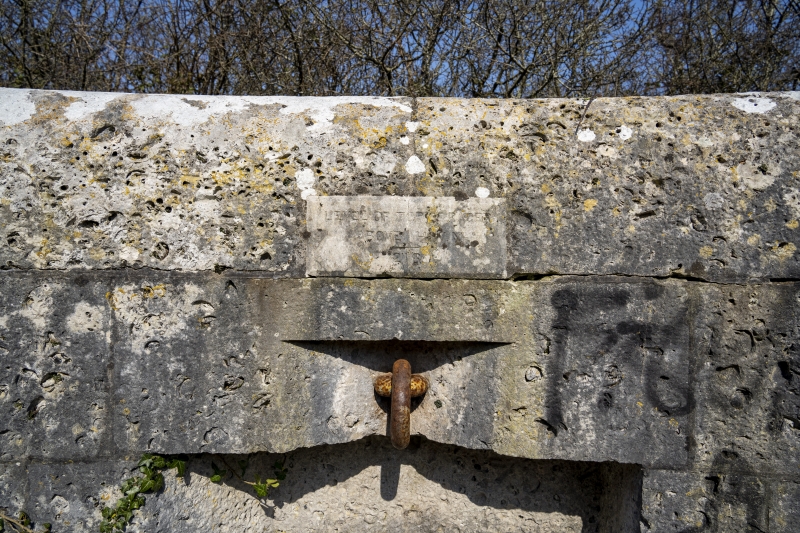
Disused gun emplacement. c1870. Portland stone, some concrete
and iron. Remains of 3 platforms plus magazine. A central
magazine with earth-covered revetment has a platform on the
axis to the NE, flanked by a platform to each side at 30
degrees; behind the magazine on the main axis is a small
single-celled unroofed building. All is sunk into the slopes
of The Verne on its N side and with a series of sunken
passageways surrounding the central mound. The central
platform has a semi-circular end in ashlar to a heavy rounded
parapet at ground level; there are 4 vertical embrasures with
segmental heads alternating with 5 mid-height square recesses
with iron bolts and rings. To each side a straight run of
rock-faced masonry wall runs approx 8m at approx 2.5m height
to a bold weathered coping, and returns at an obtuse angle for
approx 8m at same height, each with a central deep square
recess at pavement level. The centre of the emplacement has a
raised circular base in stone and concrete, with a central
iron pivot or spigot, and a ramp towards the magazine mound.
Each of the flanking platforms has a semi-octagonal
termination. Each emplacement has a small stone plaque
inscribed: LEVEL OF TOP OF RACER ABOVE HWM 216 FT.
Axially to the SW is the mound over the magazine, with a small
square vent in rock-faced stone. Retaining the mound on the SW
side is an ashlar wall approx 20m long and 4.5m high, raked at
either end above paired arched openings with bold rock-faced
jambs and voussoirs; openings filled with concrete blockwork.
Remains of a square-plan building approx 4m SW.
The battery can be seen from the higher slopes of The Verne
and commanded Portland Harbour to its SE.
Listing NGR: SY6944474052
External links are from the relevant listing authority and, where applicable, Wikidata. Wikidata IDs may be related buildings as well as this specific building. If you want to add or update a link, you will need to do so by editing the Wikidata entry.


Other nearby listed buildings
