Approximate Location Map
Large Map »
Latitude: 51.9911 / 51°59'27"N
Longitude: -2.1597 / 2°9'34"W
OS Eastings: 389132
OS Northings: 232526
OS Grid: SO891325
Mapcode National: GBR 1JR.0TZ
Mapcode Global: VH93T.J64Z
Plus Code: 9C3VXRRR+C4
Entry Name: St Mary's Cottage
Listing Date: 27 July 1973
Grade: II
Source: Historic England
Source ID: 1206034
English Heritage Legacy ID: 376737
ID on this website: 101206034
Location: Tewkesbury, Gloucestershire, GL20
County: Gloucestershire
District: Tewkesbury
Civil Parish: Tewkesbury
Built-Up Area: Tewkesbury
Traditional County: Gloucestershire
Lieutenancy Area (Ceremonial County): Gloucestershire
Church of England Parish: Tewkesbury St Mary the Virgin (Tewkesbury Abbey)
Church of England Diocese: Gloucester
Tagged with: Cottage
TEWKESBURY
SO8932 CHURCH STREET, Abbey Precincts
859-1/6/379 (South side)
27/07/73 St Mary's Cottage
GV II
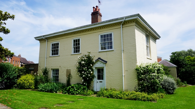
Detached house. Early to mid C19. Painted brick, low-pitched
hipped slate roof.
A simple rectangular block in 2 storeys, 3 x 1-windowed; main
front has 16-, 12-, and 16-paned sash at first floor above one
4-pane and panelled door under blind fanlight with pedimented
pilaster doorcase. Right return has large 16-pane above
3-light casement to wood lintel, and back has 16-pane at first
floor, large 16-pane ground floor, and 4-panel fielded door
off-centre, right; a further blocked doorway to left. Deep box
eaves on moulded brick dentils, large central stack.
INTERIOR has been much modified, has lateral stair with stick
balusters and swept handrail with 'Doric' newels; from an
opening at high level above the upper winders a doorway gives
to a steep divided staircase, mostly concealed by inserted
tanks and lagging; this stairway bears no relationship to the
current plan, nor can it serve a useful roof space, and may be
residue from some earlier fabric on the site.
The property appears to have been divided as 2 small
properties at some stage.
Listing NGR: SO8913232526
External links are from the relevant listing authority and, where applicable, Wikidata. Wikidata IDs may be related buildings as well as this specific building. If you want to add or update a link, you will need to do so by editing the Wikidata entry.


Other nearby listed buildings
