Approximate Location Map
Large Map »
Latitude: 50.5638 / 50°33'49"N
Longitude: -2.4382 / 2°26'17"W
OS Eastings: 369062
OS Northings: 73874
OS Grid: SY690738
Mapcode National: GBR PZ.2FNF
Mapcode Global: FRA 57SK.V9X
Plus Code: 9C2VHH76+GP
Entry Name: The Citadel, North Entrance
Listing Date: 17 May 1993
Grade: II*
Source: Historic England
Source ID: 1206120
English Heritage Legacy ID: 382026
ID on this website: 101206120
Location: Fortuneswell, Dorset, DT5
County: Dorset
Civil Parish: Portland
Built-Up Area: Fortuneswell
Traditional County: Dorset
Lieutenancy Area (Ceremonial County): Dorset
Church of England Parish: Portland All Saints
Church of England Diocese: Salisbury
Tagged with: Architectural structure
PORTLAND
SY6873 THE CITADEL, The Verne
969-1/3/172 (South side)
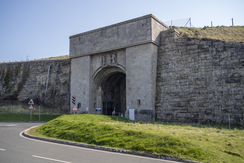
The Citadel, North Entrance
GV II*
Entrance to former military citadel, now prison. Dated 1880,
possibly from the office of Capt. E Crossman, RE, general
designer of The Citadel. Portland ashlar. Bold elliptical
moulded arch set between broad plain abutments with plinth and
small recessed gun slit, and under heavy attic course on
roll-moulding; return each side to main retaining and abutment
walls of The Citadel. Above the crown of the arch a high
relief carved Royal Arms. Inner order of moulded arch on
responds and with pair of iron gates and side railings opens
to barrel-vaulted section with 3 cross ribs, then lower
segmental moulded arch with square head and spandrels with VR
1880 beneath 4 recessed vertical gun slits. This gives to long
barrel-vaulted tunnel through which the road climbs to the
inner arch which is semi-circular with heavily rusticated
quoins and voussoirs set in rock-faced squared stone under
heavy roll-mould parapet; from the E side a long flight of
plain stone steps between ashlar walls to weathered copings
descends to roadway from main Citadel level.
Listing NGR: SY6906273874
External links are from the relevant listing authority and, where applicable, Wikidata. Wikidata IDs may be related buildings as well as this specific building. If you want to add or update a link, you will need to do so by editing the Wikidata entry.


Other nearby listed buildings
