Approximate Location Map
Large Map »
Latitude: 53.1256 / 53°7'32"N
Longitude: -1.1922 / 1°11'31"W
OS Eastings: 454154
OS Northings: 359021
OS Grid: SK541590
Mapcode National: GBR 8FK.5DB
Mapcode Global: WHDFZ.NPHP
Plus Code: 9C5W4RG5+64
Entry Name: Mausoleum 75 Metres North East of Chapel at Mansfield Cemetery
Listing Date: 21 March 1994
Grade: II
Source: Historic England
Source ID: 1207184
English Heritage Legacy ID: 391744
ID on this website: 101207184
Location: Mansfield, Nottinghamshire, NG18
County: Nottinghamshire
District: Mansfield
Electoral Ward/Division: Berry Hill
Parish: Non Civil Parish
Built-Up Area: Mansfield
Traditional County: Nottinghamshire
Lieutenancy Area (Ceremonial County): Nottinghamshire
Church of England Parish: Mansfield St Mark
Church of England Diocese: Southwell and Nottingham
Tagged with: Mausoleum
MANSFIELD
SK55NW NOTTINGHAM ROAD
924-1/3/84 (West side (off))
Mausoleum 75 metres north-east of
chapel at Mansfield Cemetery
GV II
Mausoleum. 1858, with later C19 alterations. Rock-faced stone
with ashlar dressings and flat roof. Greek Revival style.
Plinth, plain impost band and blocking course. Rock-faced
acroteria at the corners. Square plan with battered walls.
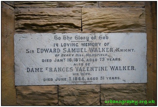
West front has moulded Egyptian-style doorcase with cornice,
and frieze with Greek inscription. Blocked doorway with
inscribed marble tablet dated 1864 and 1874. There was
formerly a rock-faced pediment, now dislodged. East front has
a cross-shaped opening. Blocking course inscribed 1858.
Listing NGR: SK5415459021
External links are from the relevant listing authority and, where applicable, Wikidata. Wikidata IDs may be related buildings as well as this specific building. If you want to add or update a link, you will need to do so by editing the Wikidata entry.


Other nearby listed buildings
