Approximate Location Map
Large Map »
Latitude: 53.1462 / 53°8'46"N
Longitude: -1.1995 / 1°11'58"W
OS Eastings: 453641
OS Northings: 361304
OS Grid: SK536613
Mapcode National: GBR 8F5.PLK
Mapcode Global: WHDFZ.K51W
Plus Code: 9C5W4RW2+F6
Entry Name: 61 and 63, West Gate
Listing Date: 17 March 1978
Grade: II
Source: Historic England
Source ID: 1207195
English Heritage Legacy ID: 391786
ID on this website: 101207195
Location: Mansfield, Nottinghamshire, NG18
County: Nottinghamshire
District: Mansfield
Electoral Ward/Division: Woodlands
Parish: Non Civil Parish
Built-Up Area: Mansfield
Traditional County: Nottinghamshire
Lieutenancy Area (Ceremonial County): Nottinghamshire
Church of England Parish: Mansfield St John with St Mary
Church of England Diocese: Southwell and Nottingham
Tagged with: Building
MANSFIELD
SK5361 WEST GATE
924-1/5/132 (South West side)
17/03/78 Nos.61 AND 63
GV II
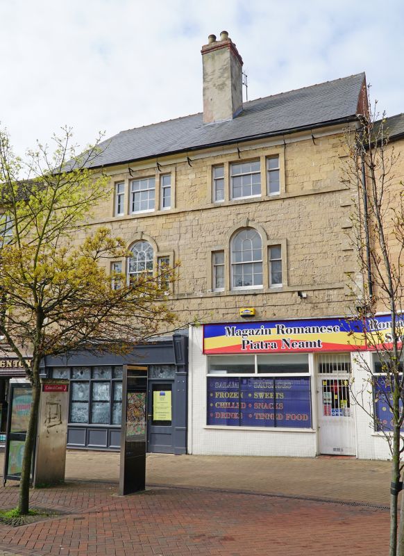
2 houses, now nightclub and shop. Mid C18, with C19 and late
C20 alterations. Coursed squared stone with ashlar dressings
and slate roof with central rendered brick stack. Quoins, sill
band to each floor, moulded eaves cornice, gutter on brackets.
3 storeys; 2-window range. 2 simplified Venetian windows with
projecting surrounds and keystones, the right one with glazing
bars, the left reglazed as a wooden-framed cross casement with
blank fanlight. Above, two 3-light windows with stone flush
mullions and projecting surrounds. Right window has a 9-pane
sash. Left window reglazed as a cross casement. Ground floor
has to left a rendered bay with large recessed entrance and to
right, a C20 door. To right, a late C20 shop front with
fascia, with an additional window overlapping the building to
right.
Listing NGR: SK5364161304
External links are from the relevant listing authority and, where applicable, Wikidata. Wikidata IDs may be related buildings as well as this specific building. If you want to add or update a link, you will need to do so by editing the Wikidata entry.


Other nearby listed buildings
