Approximate Location Map
Large Map »
Latitude: 51.4682 / 51°28'5"N
Longitude: -2.5996 / 2°35'58"W
OS Eastings: 358448
OS Northings: 174525
OS Grid: ST584745
Mapcode National: GBR C7D.1K
Mapcode Global: VH88M.WCKC
Plus Code: 9C3VFC92+75
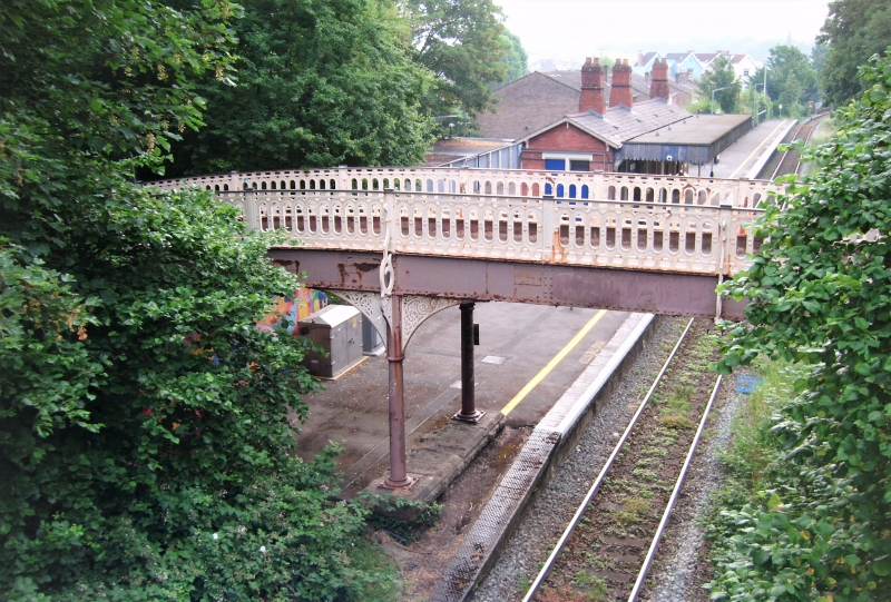
Entry Name: Footbridge at Redland Station
Listing Date: 4 March 1977
Grade: II
Source: Historic England
Source ID: 1207502
English Heritage Legacy ID: 379664
ID on this website: 101207502
Location: Cotham, Bristol, BS6
County: City of Bristol
Electoral Ward/Division: Cotham
Parish: Non Civil Parish
Built-Up Area: Bristol
Traditional County: Gloucestershire
Lieutenancy Area (Ceremonial County): Bristol
Church of England Parish: Bristol St Matthew and St Nathanael
Church of England Diocese: Bristol
Tagged with: Railway footbridge
BRISTOL
ST315874 GROVE PARK, Redland
901-1/35/1710 Footbridge at Redland Station
04/03/77
II
Railway footbridge. c1874. Cast-iron. 3-span arched bridge on
columns with fretwork brackets and oval pierced railings.
Listing NGR: ST5844874525
External links are from the relevant listing authority and, where applicable, Wikidata. Wikidata IDs may be related buildings as well as this specific building. If you want to add or update a link, you will need to do so by editing the Wikidata entry.


Other nearby listed buildings
