Latitude: 53.7589 / 53°45'32"N
Longitude: -0.3489 / 0°20'55"W
OS Eastings: 508951
OS Northings: 430437
OS Grid: TA089304
Mapcode National: GBR GKH.XY
Mapcode Global: WHGFK.MS26
Plus Code: 9C5XQM52+HF
Entry Name: Stepney Board School and Adjoining Infants School and Boundary Wall
Listing Date: 21 January 1994
Grade: II
Source: Historic England
Source ID: 1207932
English Heritage Legacy ID: 387466
ID on this website: 101207932
Location: Sculcoates, Kingston upon Hull, East Riding of Yorkshire, HU5
County: City of Kingston upon Hull
Electoral Ward/Division: Newland
Parish: Non Civil Parish
Built-Up Area: Kingston upon Hull
Traditional County: Yorkshire
Lieutenancy Area (Ceremonial County): East Riding of Yorkshire
Church of England Parish: Sculcoates St Mary
Church of England Diocese: York
Tagged with: Building
KINGSTON UPON HULL
TA0830 BEVERLEY ROAD 680-1/14/62 (East side) Stepney Board School and adjoining infants' school and boundary wall
GV II
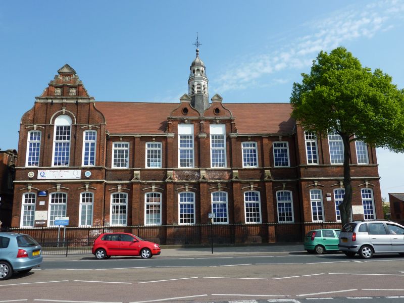
School, infants' school, and boundary wall. Dated 1886. By W Botterill. Brick with ashlar dressings and gabled and hipped plain tile roofs, the main roof topped with an elaborate octagonal wooden bell turret with lantern, leaded ogee dome and weather vane. Queen Anne style. Plinth, first-floor band and sill band, string courses, coped gables. Main block, 2 storeys plus attics; 12-window range. Windows are segment-headed glazing bar sashes. Recessed centre, 6 windows, with gabled buttresses to the ground floor and pilasters above. In the centre, a large double through-eaves dormer with shaped gabled topped with pediments and two 28-pane sashes with keystones. On either side, two 20-pane sashes with keystones. Below, six 24-pane sashes with scrolled keystones and segmental hoodmoulds. Beyond, on either side, projecting wings, 3 windows, with shouldered and stepped coped gables divided by pilasters and topped with pediments. Each has 3 square relief panels in the peak. Central 32-pane flat-headed sash with relief panel in tympanum, flanked by single 21-pane sashes, 2 of them partly reglazed. These windows have scroll keystones and linked hoodmould. Below, central 24-pane sash flanked by single 18-pane sashes, 2 of them partly reglazed, all with scroll keystones and linked hoodmoulds. Right return has two 15-pane sashes and above, a hipped dormer with a 2-light casement. Below, two 18-pane sashes. 2-storey rear wing, 3 windows, has to right a projecting gable, 3 storeys, 2-window range, and to its right a hipped projection, 2 storeys; 3-window range. To right, single-storey range, 3 windows, then lower single-story block, 3 bays, linked to Infants' School. Infants' School, single-storey, has coped gables and a square bell turret with leaded ogee dome and finial. Facing gable, to street, has three 28-pane sashes, one partly reglazed. To left, a double gabled wing with a door and overlight to right, and 3 small windows to left. To right, a larger wing with a buttress flanked by two 20-pane sashes. Brick boundary wall to right return, has gabled blue brick coping and 2 pairs of square gatepiers. Lower section to right. Approx 100m long. (Hull City Records Office: OBLM 7228).
Listing NGR: TA0895130437
External links are from the relevant listing authority and, where applicable, Wikidata. Wikidata IDs may be related buildings as well as this specific building. If you want to add or update a link, you will need to do so by editing the Wikidata entry.


Other nearby listed buildings