Approximate Location Map
Large Map »
Latitude: 51.2938 / 51°17'37"N
Longitude: 0.4081 / 0°24'29"E
OS Eastings: 567998
OS Northings: 157716
OS Grid: TQ679577
Mapcode National: GBR NPC.VBL
Mapcode Global: VHJM5.1R31
Plus Code: 9F327CV5+G7
Entry Name: K6 Telephone Kiosk
Listing Date: 27 January 1988
Grade: II
Source: Historic England
Source ID: 1209111
English Heritage Legacy ID: 392411
ID on this website: 101209111
Location: West Malling, Tonbridge and Malling, Kent, ME19
County: Kent
District: Tonbridge and Malling
Civil Parish: West Malling
Built-Up Area: West Malling
Traditional County: Kent
Lieutenancy Area (Ceremonial County): Kent
Church of England Parish: West Malling St Mary
Church of England Diocese: Rochester
Tagged with: K6 telephone box
WEST MALLING
TQ6857 HIGH STREET
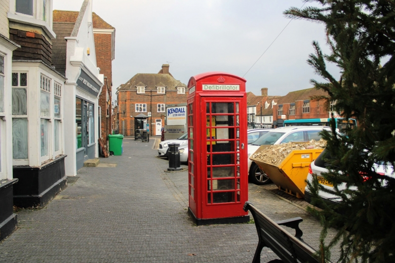
1156-0/3/51 K6 Telephone Kiosk
27/01/88
II
Telephone kiosk, type K6. Designed 1935 by Sir Giles Gilbert
Scott. Made by various contractors. Cast-iron. Square kiosk
with domed roof. Unperforated crowns to top panels and margin
glazing to windows and doors.
Listing NGR: TQ6799857716
External links are from the relevant listing authority and, where applicable, Wikidata. Wikidata IDs may be related buildings as well as this specific building. If you want to add or update a link, you will need to do so by editing the Wikidata entry.


Other nearby listed buildings
