Approximate Location Map
Large Map »
Latitude: 52.3395 / 52°20'22"N
Longitude: -2.2798 / 2°16'47"W
OS Eastings: 381030
OS Northings: 271307
OS Grid: SO810713
Mapcode National: GBR 0C0.6FS
Mapcode Global: VH920.FGLC
Plus Code: 9C4V8PQC+R3
Entry Name: 28 and 29, High Street
Listing Date: 25 June 1973
Last Amended: 11 October 1991
Grade: II
Source: Historic England
Source ID: 1209457
English Heritage Legacy ID: 393341
ID on this website: 101209457
Location: Stourport-on-Severn, Wyre Forest, Worcestershire, DY13
County: Worcestershire
District: Wyre Forest
Civil Parish: Stourport-on-Severn
Built-Up Area: Stourport-on-Severn
Traditional County: Worcestershire
Lieutenancy Area (Ceremonial County): Worcestershire
Church of England Parish: Stourport-on-Severn and Wilden
Church of England Diocese: Worcester
Tagged with: Building
STOURPORT ON SEVERN
SO8171SW HIGH STREET
589-1/9/34 (South East side)
25/06/73 Nos.28 AND 29
(Formerly Listed as:
HIGH STREET
Nos.28-30 (Consecutive))
GV II
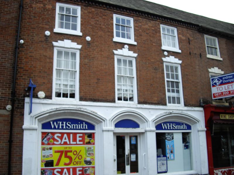
Pair of shops, formerly with dwellings over. c1800. Brick with
graded slate roof. 3-storeyed, each of 3 bays. No.28 has shop
front with central doorway and 3 stilted arches with heavy
moulding, circa 1880. No.29 has strongly projecting console
brackets to fascia and slender fluted wood shafts and spandrel
decoration in angle of window panes. Upper windows are 15-pane
sashes in No.28, twelve-pane in No.29, smaller to attic
storey. First floor windows have flat arched stuccoed heads
with voussoirs and moulded keystones. Dentilled eaves band to
No.28, modillion cornice to No.29. Axial stack on original
property division.
Listing NGR: SO8103071307
External links are from the relevant listing authority and, where applicable, Wikidata. Wikidata IDs may be related buildings as well as this specific building. If you want to add or update a link, you will need to do so by editing the Wikidata entry.


Other nearby listed buildings
