Approximate Location Map
Large Map »
Latitude: 52.3397 / 52°20'23"N
Longitude: -2.2794 / 2°16'45"W
OS Eastings: 381058
OS Northings: 271332
OS Grid: SO810713
Mapcode National: GBR 0C0.6JZ
Mapcode Global: VH920.FGT6
Plus Code: 9C4V8PQC+V6
Entry Name: 22, 23 and 23A, High Street
Listing Date: 11 October 1991
Grade: II
Source: Historic England
Source ID: 1210132
English Heritage Legacy ID: 393340
ID on this website: 101210132
Location: Stourport-on-Severn, Wyre Forest, Worcestershire, DY13
County: Worcestershire
District: Wyre Forest
Civil Parish: Stourport-on-Severn
Built-Up Area: Stourport-on-Severn
Traditional County: Worcestershire
Lieutenancy Area (Ceremonial County): Worcestershire
Church of England Parish: Stourport-on-Severn and Wilden
Church of England Diocese: Worcester
Tagged with: Building
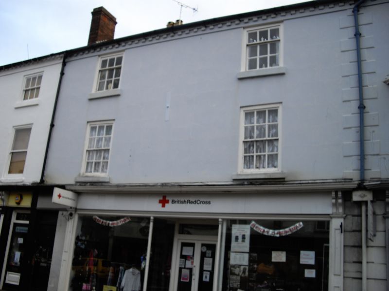
STOURPORT ON SEVERN
SO8171SW HIGH STREET
589-1/9/33 (South East side)
Nos.22, 23 AND 23A
GV II
Pair of shops, originally with dwellings over. c1800, stucco
over brick with Welsh slate roof. 3-storeyed, divided into two
unequal units each of two bays. Early C20 shop fronts have
slender wood shafts and paired console brackets to fascia.
Pedimented doorway to passage to right. Upper windows are
12-pane sashes, though some have been renewed in original
openings. 2 corbelled canted bays in 23. Angle quoins, plain
eaves band, gable end stack. Included for group value.
Listing NGR: SO8105871332
External links are from the relevant listing authority and, where applicable, Wikidata. Wikidata IDs may be related buildings as well as this specific building. If you want to add or update a link, you will need to do so by editing the Wikidata entry.


Other nearby listed buildings
