Latitude: 51.5239 / 51°31'25"N
Longitude: -0.0945 / 0°5'40"W
OS Eastings: 532288
OS Northings: 182269
OS Grid: TQ322822
Mapcode National: GBR Q7.XX
Mapcode Global: VHGQT.9YWP
Plus Code: 9C3XGWF4+G5
Entry Name: Whitbread's Stables
Listing Date: 10 October 1990
Grade: II
Source: Historic England
Source ID: 1209702
English Heritage Legacy ID: 368907
ID on this website: 101209702
Location: St Luke's, Islington, London, EC1Y
County: London
District: Islington
Electoral Ward/Division: Bunhill
Parish: Non Civil Parish
Built-Up Area: Islington
Traditional County: Middlesex
Lieutenancy Area (Ceremonial County): Greater London
Church of England Parish: St Giles Cripplegate
Church of England Diocese: London
Tagged with: Stable
TQ3282SW
635-1/75/406
ISLINGTON
GARRETT STREET (South side)
Whitbread's Stables
10/10/90
II
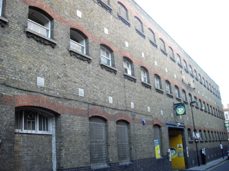
Stables. Dated 1897 on a cartouche above first-floor windows inscribed 'WHITBREAD & CO. LTD. STABLING. ERECTED 1897'. Yellow brick set in English bond with dressings of blue and red brick, composition stone and possibly terracotta, roof obscured by parapet.
Three storeys, the third storey blank, and twenty-one-window range. Base of blue brick; flat-arched carriage entrance under eighth and ninth windows from the east, wooden gates, probably original, with long iron hinges. All windows segmental-arched with heads of gauged red brick, the heads linked by four courses of red brick in a band. Four ground-floor windows of conventional height to left of entrance, the outer one now partly blocked; one smaller window beyond that with sill of composition stone and apron possibly of terracotta; all other windows in the Garrett Street front are of this type, and those to the second floor are blank; parapet.
On the south side there is a ramp to two storeys east of the entrance, the upper flight carried on wrought-iron beams and with a late C20 roof; west of the entrance the block is detailed broadly as for Garrett Street front. Single-storey farrier's shop under a lean-to roof abuts the south side of the ramps, probably not part of the original building.
INTERIOR: three stalls, harness and tack room, all glazed internally, give directly onto the yard from the west block; otherwise the three storeys of the west block and the narrower east block in front of the ramps consist almost entirely of long rooms whose roofs are carried on two rows of cast-iron columns; the horses's stalls occupy the bays between the columns on the ground and first floors, but the fittings of the stalls are of C20 date; the third floor has no fittings.
Listing NGR: TQ3228082265
External links are from the relevant listing authority and, where applicable, Wikidata. Wikidata IDs may be related buildings as well as this specific building. If you want to add or update a link, you will need to do so by editing the Wikidata entry.


Other nearby listed buildings