Approximate Location Map
Large Map »
Latitude: 52.3402 / 52°20'24"N
Longitude: -2.2784 / 2°16'42"W
OS Eastings: 381131
OS Northings: 271388
OS Grid: SO811713
Mapcode National: GBR 0C0.6SG
Mapcode Global: VH920.GFCT
Plus Code: 9C4V8PRC+3M
Entry Name: 10, 11 and 12, High Street
Listing Date: 11 October 1991
Grade: II
Source: Historic England
Source ID: 1210117
English Heritage Legacy ID: 393333
ID on this website: 101210117
Location: Stourport-on-Severn, Wyre Forest, Worcestershire, DY13
County: Worcestershire
District: Wyre Forest
Civil Parish: Stourport-on-Severn
Built-Up Area: Stourport-on-Severn
Traditional County: Worcestershire
Lieutenancy Area (Ceremonial County): Worcestershire
Church of England Parish: Stourport-on-Severn and Wilden
Church of England Diocese: Worcester
Tagged with: Building
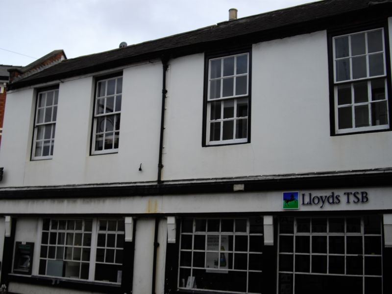
STOURPORT ON SEVERN
SO8171SW HIGH STREET
589-1/9/26 (South East side)
Nos.10, 11 AND 12
GV II
Bank, probably originally a pair of shops and dwellings. Part
c1800, the rest c1820. Rendered over brick with Welsh slate
roof. Northern block 2 storeyed, 4 bays. The earlier southern
block is 3-storeyed, 2 bays. Ground floor now has continous
shop front, but upper storey has 12 pane flush framed sash
windows. Dentilled eaves to northern block, modillions to
south. Included for group value.
Listing NGR: SO8113171388
External links are from the relevant listing authority and, where applicable, Wikidata. Wikidata IDs may be related buildings as well as this specific building. If you want to add or update a link, you will need to do so by editing the Wikidata entry.


Other nearby listed buildings
