Approximate Location Map
Large Map »
Latitude: 52.3401 / 52°20'24"N
Longitude: -2.2787 / 2°16'43"W
OS Eastings: 381106
OS Northings: 271369
OS Grid: SO811713
Mapcode National: GBR 0C0.6QB
Mapcode Global: VH920.GF5Y
Plus Code: 9C4V8PRC+2G
Entry Name: 15, 16 and 17, High Street
Listing Date: 12 June 1975
Last Amended: 11 October 1991
Grade: II
Source: Historic England
Source ID: 1210122
English Heritage Legacy ID: 393335
ID on this website: 101210122
Location: Stourport-on-Severn, Wyre Forest, Worcestershire, DY13
County: Worcestershire
District: Wyre Forest
Civil Parish: Stourport-on-Severn
Built-Up Area: Stourport-on-Severn
Traditional County: Worcestershire
Lieutenancy Area (Ceremonial County): Worcestershire
Church of England Parish: Stourport-on-Severn and Wilden
Church of England Diocese: Worcester
Tagged with: Building
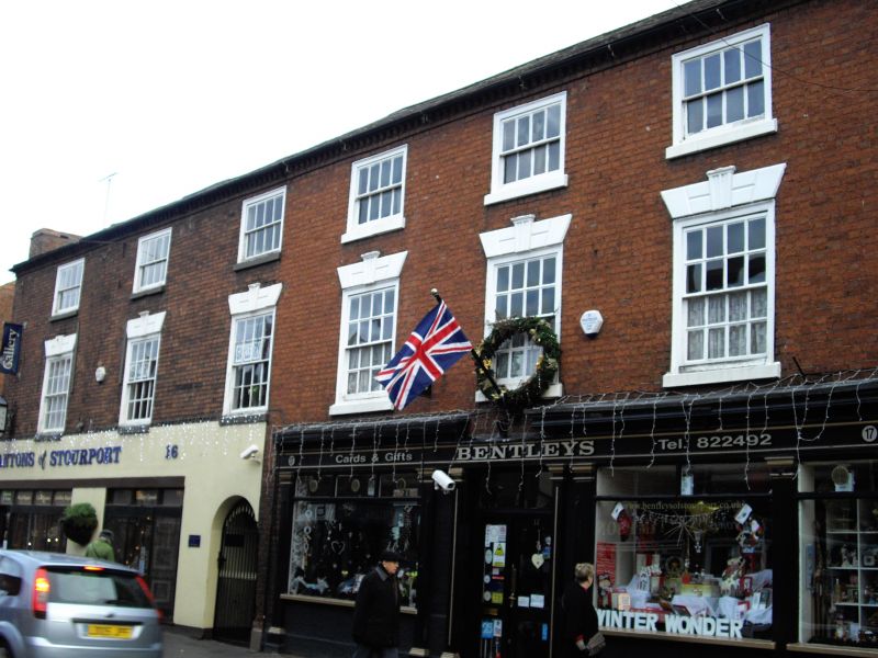
STOURPORT ON SEVERN
SO8171SW HIGH STREET
589-1/9/28 (South East side)
12/06/75 Nos.15, 16 AND 17
GV II
3 shops with dwellings over. c1800. Brick with graded slate
roof. A single build, 3-storeyed, 3 wide, then 3 narrow bays.
One early C20 shop front to 17, with moulded wood pilasters
supporting fascia and forming architrave of central doorway.
Other shop fronts renewed. Upper windows are 12-pane, flush
framed sashes with flat arched stuccoed heads with voussoirs
and moulded keystones. Modillion eaves cornice.
Listing NGR: SO8109971359
External links are from the relevant listing authority and, where applicable, Wikidata. Wikidata IDs may be related buildings as well as this specific building. If you want to add or update a link, you will need to do so by editing the Wikidata entry.


Other nearby listed buildings
