Approximate Location Map
Large Map »
Latitude: 52.34 / 52°20'23"N
Longitude: -2.2789 / 2°16'43"W
OS Eastings: 381095
OS Northings: 271359
OS Grid: SO810713
Mapcode National: GBR 0C0.6P8
Mapcode Global: VH920.GG30
Plus Code: 9C4V8PQC+XC
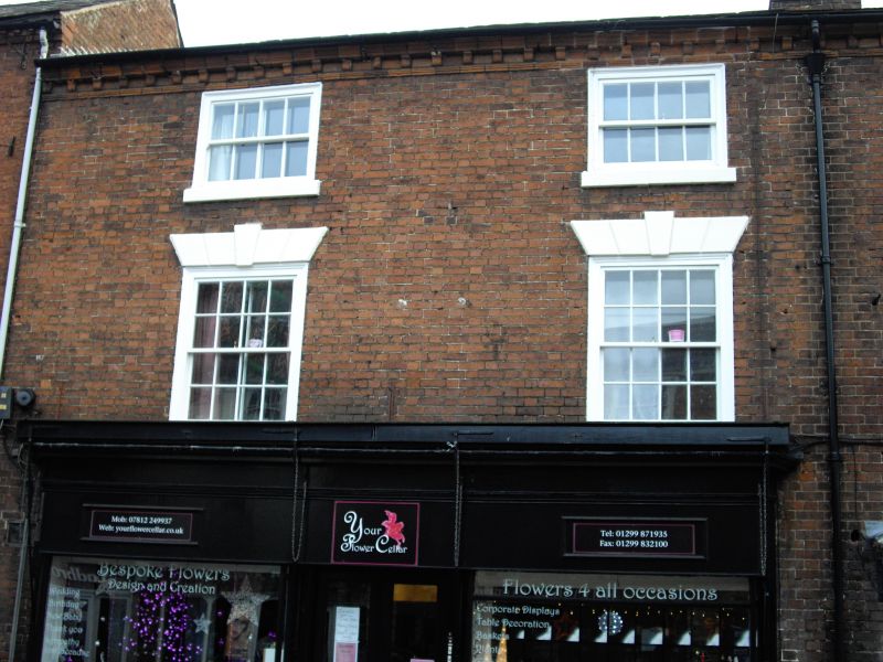
Entry Name: 18, High Street
Listing Date: 9 November 1971
Grade: II
Source: Historic England
Source ID: 1292642
English Heritage Legacy ID: 393336
ID on this website: 101292642
Location: Stourport-on-Severn, Wyre Forest, Worcestershire, DY13
County: Worcestershire
District: Wyre Forest
Civil Parish: Stourport-on-Severn
Built-Up Area: Stourport-on-Severn
Traditional County: Worcestershire
Lieutenancy Area (Ceremonial County): Worcestershire
Church of England Parish: Stourport-on-Severn and Wilden
Church of England Diocese: Worcester
Tagged with: Building
STOURPORT ON SEVERN
SO8171SW HIGH STREET
589-1/9/29 (South East side)
09/11/71 No.18
GV II
Shop. c1800. Brick with Welsh slate roof. 3-storeyed, 2 bays
with early C20 shop front with central doorway and slim
columns supporting fascia. Upper windows are 6-pane sashes
with flat arched stuccoed heads with voussoirs and keystones.
Deep modillion eaves band, gable end stack.
Listing NGR: SO8108771353
External links are from the relevant listing authority and, where applicable, Wikidata. Wikidata IDs may be related buildings as well as this specific building. If you want to add or update a link, you will need to do so by editing the Wikidata entry.


Other nearby listed buildings
