Latitude: 50.1186 / 50°7'7"N
Longitude: -5.5335 / 5°32'0"W
OS Eastings: 147503
OS Northings: 30264
OS Grid: SW475302
Mapcode National: GBR DXQC.G59
Mapcode Global: VH12Z.18HW
Plus Code: 9C2P4F98+FH
Entry Name: Former Penzance lifeboat house
Listing Date: 16 March 1987
Grade: II
Source: Historic England
Source ID: 1210218
English Heritage Legacy ID: 351304
ID on this website: 101210218
Location: Penzance, Cornwall, TR18
County: Cornwall
Civil Parish: Penzance
Built-Up Area: Penzance
Traditional County: Cornwall
Lieutenancy Area (Ceremonial County): Cornwall
Church of England Parish: Penzance St John the Baptist
Church of England Diocese: Truro
Tagged with: House
This list entry was subjected to a Minor Enhancement 30 May 2024 to amend details in the description, name and address and reformat the text to current standards
SW 4730
5/100
PENZANCE
WHARF ROAD
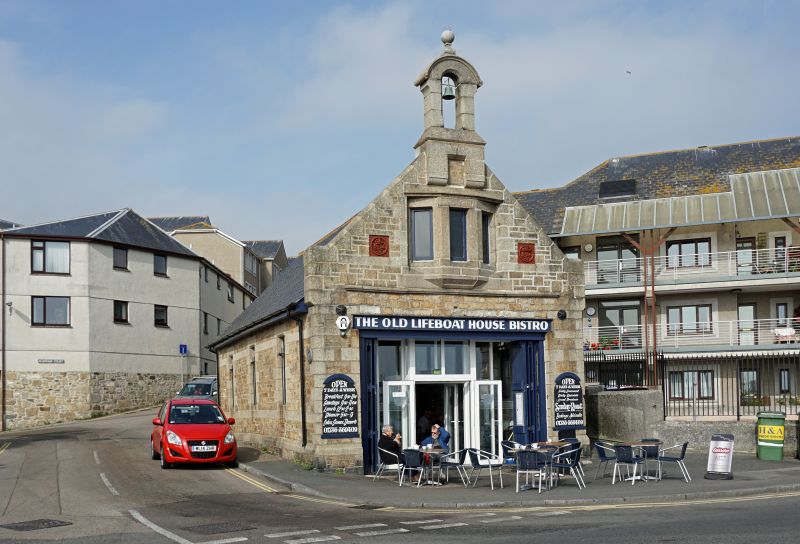
Former Penzance lifeboat house
(Formerly listed as Old Lifeboat House)
II
Former lifeboat house, now in commercial use. 1884.
MATERIALS: Square coursed granite with ashlar dressings, slate roof.
EXTERIOR: Single-storey rectangular shed with double doors (modern), under a replaced lintel. Three-light oriel with granite mullions over door, flanked by terracotta roundels with the RNLI crest. Coped gable with kneelers, arched bellcote with ball finial. Long elevation with three square-headed small-paned windows.
HISTORY: The lifeboat was kept at Penzance from 1803-1917 and in this building 1885-1917. It is one of the best surviving examples in Cornwall.
Listing NGR: SW4750330264
External links are from the relevant listing authority and, where applicable, Wikidata. Wikidata IDs may be related buildings as well as this specific building. If you want to add or update a link, you will need to do so by editing the Wikidata entry.


Other nearby listed buildings