Approximate Location Map
Large Map »
Latitude: 52.2977 / 52°17'51"N
Longitude: -0.3907 / 0°23'26"W
OS Eastings: 509841
OS Northings: 267839
OS Grid: TL098678
Mapcode National: GBR H1G.XQR
Mapcode Global: VHFPJ.5HTY
Plus Code: 9C4X7JX5+3P
Entry Name: Moreto
Listing Date: 28 April 1983
Grade: II
Source: Historic England
Source ID: 1210293
English Heritage Legacy ID: 394922
ID on this website: 101210293
Location: Kimbolton, Huntingdonshire, Cambridgeshire, PE28
County: Cambridgeshire
District: Huntingdonshire
Civil Parish: Kimbolton
Built-Up Area: Kimbolton
Traditional County: Huntingdonshire
Lieutenancy Area (Ceremonial County): Cambridgeshire
Church of England Parish: Kimbolton St Andrew
Church of England Diocese: Ely
Tagged with: Building
KIMBOLTON GRASS YARD
TL 095675
(SOUTH SIDE)
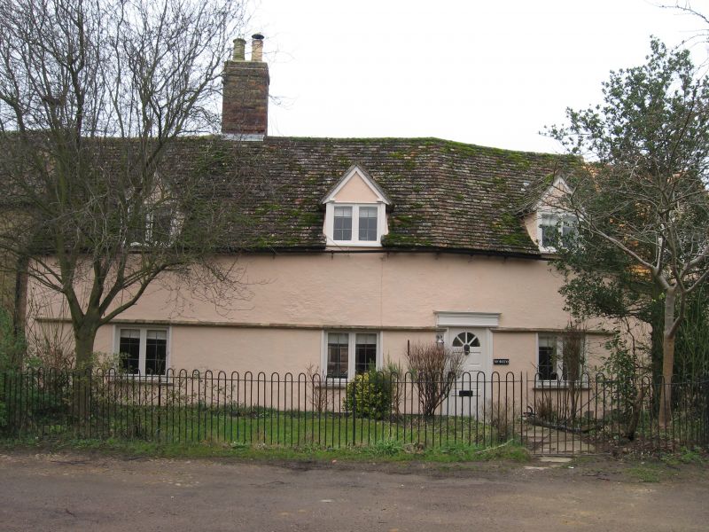
6/30 NO. 2 (MORETO)
GV II
Possibly an original C17 timber-framed cottage with lobby entry
and extended to the west by another bay. One storey and attic.
Roughcast rendered. Old plain tile roof. Tall ridge stack.
Three gabled dormer windows. Three casement windows and modern
panelled door to west.
Listing NGR: TL0984167839
External links are from the relevant listing authority and, where applicable, Wikidata. Wikidata IDs may be related buildings as well as this specific building. If you want to add or update a link, you will need to do so by editing the Wikidata entry.


Other nearby listed buildings
