Latitude: 50.3278 / 50°19'40"N
Longitude: -4.7967 / 4°47'47"W
OS Eastings: 201042
OS Northings: 51279
OS Grid: SX010512
Mapcode National: GBR ZX.BHCB
Mapcode Global: FRA 08V5.F3N
Plus Code: 9C2Q86H3+48
Entry Name: White House
Listing Date: 11 March 1974
Grade: II
Source: Historic England
Source ID: 1212095
English Heritage Legacy ID: 396622
ID on this website: 101212095
Location: Tregorrick, Cornwall, PL26
County: Cornwall
Civil Parish: Pentewan Valley
Traditional County: Cornwall
Lieutenancy Area (Ceremonial County): Cornwall
Church of England Parish: St Austell
Church of England Diocese: Truro
Tagged with: House
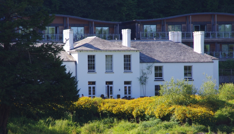
TREGORRICK
1.
1584A
White House
SX 05 SW 9/567
II
2.
An early C19 country house with plastered walls and hipped slate roof.
Plastered octagonal chimney stacks. 7 window front. 2 storeys. Centre
block of 3 tall sashes with glazing bars, bracketed eaves. Flanked by
two lower 2 storey wings of 2 windows each. Flat roofed porch with cornice
and flat pilasters, glazed door and rectangular fanlight.
Listing NGR: SX0104251279
External links are from the relevant listing authority and, where applicable, Wikidata. Wikidata IDs may be related buildings as well as this specific building. If you want to add or update a link, you will need to do so by editing the Wikidata entry.


Other nearby listed buildings