Latitude: 51.7907 / 51°47'26"N
Longitude: -1.4802 / 1°28'48"W
OS Eastings: 435950
OS Northings: 210357
OS Grid: SP359103
Mapcode National: GBR 6VL.QL4
Mapcode Global: VHC02.98C2
Plus Code: 9C3WQGR9+7W
Entry Name: Milestone
Listing Date: 3 March 1988
Grade: II
Source: Historic England
Source ID: 1214101
English Heritage Legacy ID: 398839
ID on this website: 101214101
Location: Woodgreen, West Oxfordshire, OX28
County: Oxfordshire
District: West Oxfordshire
Civil Parish: Witney
Built-Up Area: Witney
Traditional County: Oxfordshire
Lieutenancy Area (Ceremonial County): Oxfordshire
Church of England Parish: Witney
Church of England Diocese: Oxford
Tagged with: Milestone
WITNEY WOOD GREEN
SP3510SE (East side)
9/270 Milestone
-
II
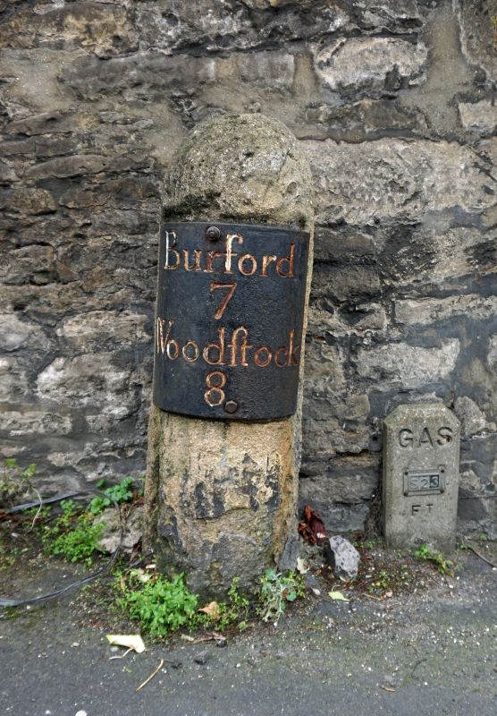
Milestone. Mid/late C18. Limestone. Iron inscription plate reads
Burford/7/Woodstock/8. The road was turnpiked in 1751.
(Turnpike Roads of Oxfordshire, Oxfordshire Museums Information Sheet No.5,
1977).
Listing NGR: SP3595010357
External links are from the relevant listing authority and, where applicable, Wikidata. Wikidata IDs may be related buildings as well as this specific building. If you want to add or update a link, you will need to do so by editing the Wikidata entry.


Other nearby listed buildings