Approximate Location Map
Large Map »
Latitude: 54.0436 / 54°2'36"N
Longitude: -2.7851 / 2°47'6"W
OS Eastings: 348689
OS Northings: 461129
OS Grid: SD486611
Mapcode National: GBR 8PZP.V7
Mapcode Global: WH847.6M1H
Plus Code: 9C6V26V7+CX
Entry Name: Gate Piers, Gates and Walls to Williamson Park
Listing Date: 13 March 1995
Grade: II
Source: Historic England
Source ID: 1214963
English Heritage Legacy ID: 383356
ID on this website: 101214963
Location: Williamson Park, Golgotha, Lancaster, Lancashire, LA1
County: Lancashire
District: Lancaster
Electoral Ward/Division: John O'Gaunt
Parish: Non Civil Parish
Built-Up Area: Lancaster
Traditional County: Lancashire
Lieutenancy Area (Ceremonial County): Lancashire
Church of England Parish: Lancaster Christ Church
Church of England Diocese: Blackburn
LANCASTER
SD4861 WYRESDALE ROAD
1685-1/5/352 (East side)
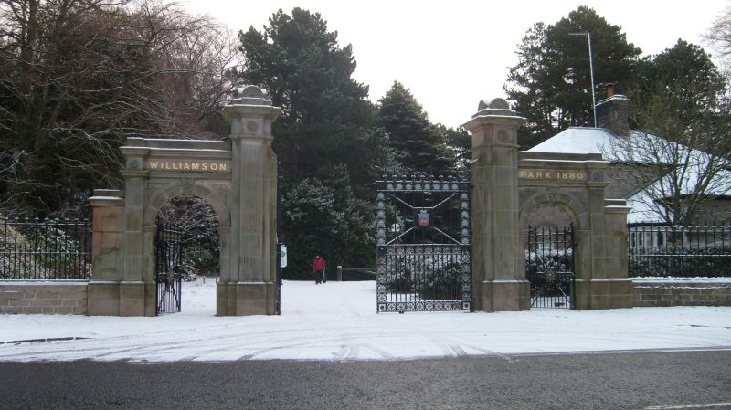
Gate piers, gates and walls to
Williamson Park
GV II
Gateway. 1880. Sandstone ashlar with cast and wrought-iron
gates. The gate piers flanking the main carriageway are of
square plan with moulded bases, fluted pilasters carved with
rosettes on their friezes, moulded cornices, and are capped by
stones whose semicircular elevations have fan-like carving.
To left and right are pedestrian entrances with moulded
semicircular arches springing from moulded imposts and with
carved keystones and spandrel decoration. At their outer sides
are fluted pilasters, and above a moulded cornice and blocking
course. The friezes are carved: 'WILLIAMSON' and 'PARK 1880'.
To each side are low stone walls of S-plan carrying railings
between rectangular piers with cornices and sunken panels. The
railings have ball-and-spike finials.
The pedestrian gates have friezes of roundels and are
cross-braced with a central boss with foliage decoration. The
central gates have borders of roundels and have shields of
arms in the centres of their upper panels.
HISTORY: Williamson Park was laid out on the site of disused
quarries and moorland. Some development began during the
Cotton Famine of the 1860s, but large-scale development only
began during the 1870s when James Williamson (Senior) paid to
have the landscape developed to the designs of Mr Maclean of
Castle Donnington. James Williamson (Junior) handed the park
over to Lancaster Corporation in 1881.
Listing NGR: SD4868961129
External links are from the relevant listing authority and, where applicable, Wikidata. Wikidata IDs may be related buildings as well as this specific building. If you want to add or update a link, you will need to do so by editing the Wikidata entry.


Other nearby listed buildings
