Approximate Location Map
Large Map »
Latitude: 51.5371 / 51°32'13"N
Longitude: -2.454 / 2°27'14"W
OS Eastings: 368609
OS Northings: 182120
OS Grid: ST686821
Mapcode National: GBR JX.GHF5
Mapcode Global: VH88B.FM1J
Plus Code: 9C3VGGPW+RC
Entry Name: 309-311, Badminton Road
Listing Date: 15 August 1985
Grade: II
Source: Historic England
Source ID: 1215173
English Heritage Legacy ID: 400214
ID on this website: 101215173
Location: Mayshill, South Gloucestershire, BS36
County: South Gloucestershire
Civil Parish: Westerleigh
Traditional County: Gloucestershire
Lieutenancy Area (Ceremonial County): Gloucestershire
Church of England Parish: Coalpit Heath
Church of England Diocese: Bristol
Tagged with: Building
ST 68 SE WESTERLEIGH C.P. BADMINTON ROAD, Mayshill (west side)
1/316 No. 309-11
- II
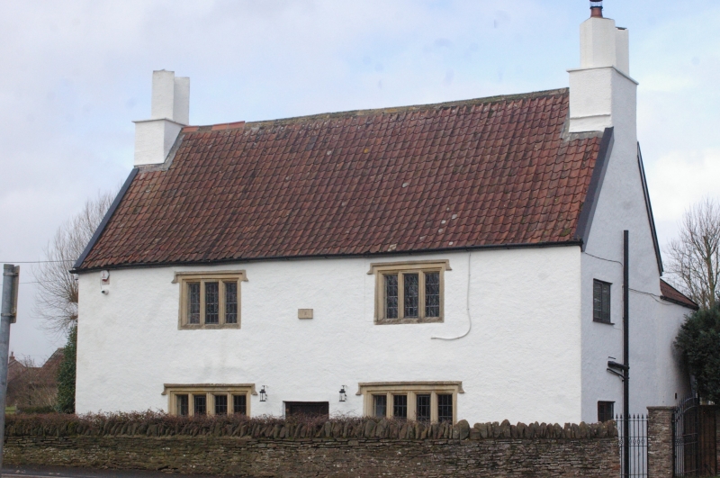
House. Dated 1642 on front, C19 and C20 alterations and additions. Rubble,
rendered with limestone dressings, pantiled roof with gable stacks and diagonal
chimneys to right, double Roman tiles to rear. Cross passage plan, L-plan with
stair turret in angle to rear. 2 storeys and 2 windows, ground floor has two
4-light casements with ovolo mullions, king mullion and hood mould, central C20
door, first floor has 2 similar 3-light casements, central datestone; all windows
C20 replacements. Left return has C20 window at ground and first floor, and
door. Rear has all C20 windows, lean-to attached to left and right. Interior:
chamfered beams, room to left (former hall) has small decorated spice cupboard
without door; stair has circular newel post with separate treads, risers, attic
flight removed. First floor right has blocked fireplace with plaster overmantel
remaining dated 1642. (Sources: Hall, L. : Rural Houses of North Avon and South
Gloucestershire 1400-1720. 1983).
Listing NGR: ST6860982120
External links are from the relevant listing authority and, where applicable, Wikidata. Wikidata IDs may be related buildings as well as this specific building. If you want to add or update a link, you will need to do so by editing the Wikidata entry.


Other nearby listed buildings
