Latitude: 53.1447 / 53°8'40"N
Longitude: -1.1967 / 1°11'48"W
OS Eastings: 453827
OS Northings: 361141
OS Grid: SK538611
Mapcode National: GBR 8F5.XZ3
Mapcode Global: WHDFZ.L7C1
Plus Code: 9C5W4RV3+V8
Entry Name: Westgate House
Listing Date: 30 April 1975
Grade: II
Source: Historic England
Source ID: 1215465
English Heritage Legacy ID: 391776
ID on this website: 101215465
Location: Mansfield, Nottinghamshire, NG18
County: Nottinghamshire
District: Mansfield
Electoral Ward/Division: Woodlands
Parish: Non Civil Parish
Built-Up Area: Mansfield
Traditional County: Nottinghamshire
Lieutenancy Area (Ceremonial County): Nottinghamshire
Church of England Parish: Mansfield St John with St Mary
Church of England Diocese: Southwell and Nottingham
Tagged with: House
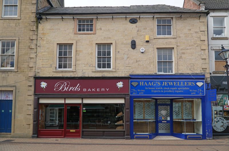
MANSFIELD
SK5361 WEST GATE
924-1/5/118 (South West side)
30/04/75 Nos.1 AND 1A
Westgate House
GV II
2 houses, now 2 shops. Mid C18, with late C19 and late C20
alterations. Coursed squared stone, painted, with stone
dressings and slate roof. Rebated eaves with gutter on
brackets, quoins to right corner. 3 storeys; 3-window range of
12 pane sashes, the right one set lower. Above, an unequally
hung 12-pane sash to left, and a larger 9-pane sash to right.
All these windows have projecting surrounds. Ground floor has
2 late C20 shop fronts with plastic fascias.
Listing NGR: SK5382761141
External links are from the relevant listing authority and, where applicable, Wikidata. Wikidata IDs may be related buildings as well as this specific building. If you want to add or update a link, you will need to do so by editing the Wikidata entry.


Other nearby listed buildings