Approximate Location Map
Large Map »
Latitude: 53.6121 / 53°36'43"N
Longitude: -1.828 / 1°49'40"W
OS Eastings: 411477
OS Northings: 412853
OS Grid: SE114128
Mapcode National: GBR HVPN.1W
Mapcode Global: WHCB6.WGQR
Plus Code: 9C5WJ56C+RR
Entry Name: Barn at Pond Farm Facing Road
Listing Date: 29 September 1978
Grade: II
Source: Historic England
Source ID: 1216308
English Heritage Legacy ID: 401590
ID on this website: 101216308
Location: South Crosland, Kirklees, West Yorkshire, HD4
County: Kirklees
Electoral Ward/Division: Crosland Moor and Netherton
Parish: Non Civil Parish
Built-Up Area: Netherton
Traditional County: Yorkshire
Lieutenancy Area (Ceremonial County): West Yorkshire
Church of England Parish: South Crosland Holy Trinity
Church of England Diocese: Leeds
Tagged with: Barn
MIDWAY
1.
5113
(East Side)
South Crosland
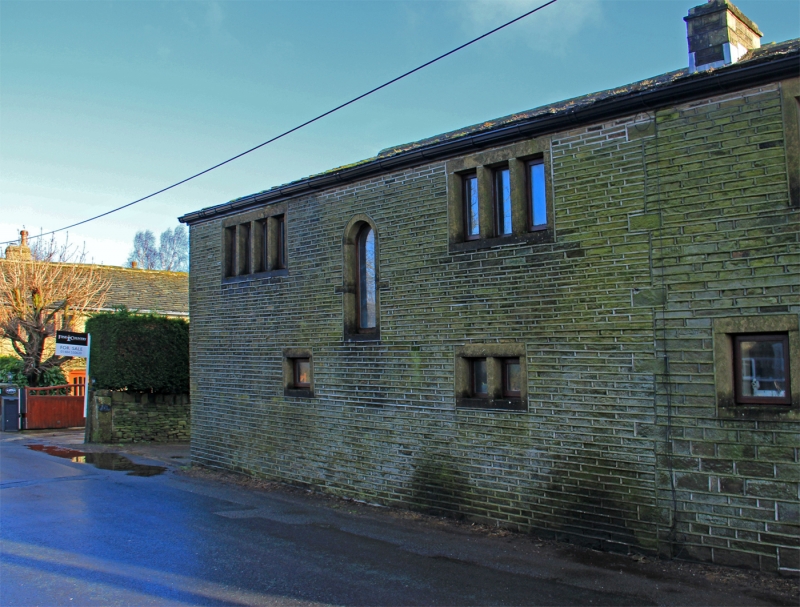
Barn at Pond Farm
facing road
SE 1112 50/938
II
2.
Probably C18. Hammer-dressed stone. Pitched stone slate roof. Various openings
with monolithic lintels, one in north gable end with slightly recessed stone
frame. Queen post trusses.
Listing NGR: SE1147712853
External links are from the relevant listing authority and, where applicable, Wikidata. Wikidata IDs may be related buildings as well as this specific building. If you want to add or update a link, you will need to do so by editing the Wikidata entry.


Other nearby listed buildings
