Latitude: 52.2222 / 52°13'19"N
Longitude: 1.5775 / 1°34'38"E
OS Eastings: 644442
OS Northings: 264252
OS Grid: TM444642
Mapcode National: GBR XQ9.PN4
Mapcode Global: VHM7Q.9D9T
Plus Code: 9F436HCG+VX
Entry Name: Barn at Abbey Farm
Listing Date: 13 March 1951
Last Amended: 2 August 1983
Grade: II
Source: Historic England
Source ID: 1216380
English Heritage Legacy ID: 401029
ID on this website: 101216380
Location: East Suffolk, IP16
County: Suffolk
District: East Suffolk
Civil Parish: Leiston
Traditional County: Suffolk
Lieutenancy Area (Ceremonial County): Suffolk
Church of England Parish: Leiston St Margaret
Church of England Diocese: St.Edmundsbury and Ipswich
Tagged with: Barn
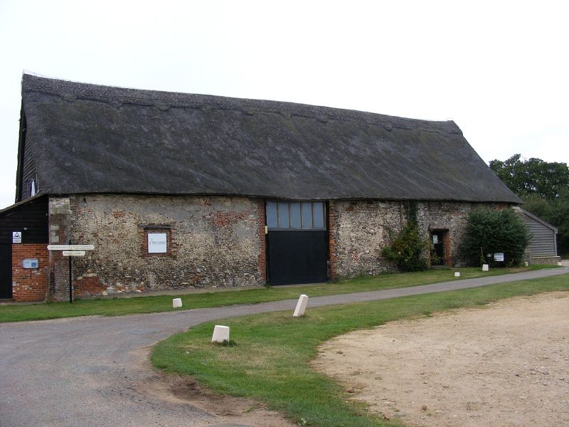
TM 46 SW LEISTON-CUM-SIZEWELL ABBEY ROAD
4/29 Barn at Abbey Farm
(formerly listed with
St Mary's Abbey)
13.3.51
GV II
Barn. C15. Brick and flint with weatherboarded end gables; thatched. Stepped
buttresses to corners. 7 bays. Believed to be part of the original abbey
buildings.
Listing NGR: TM4444264252
External links are from the relevant listing authority and, where applicable, Wikidata. Wikidata IDs may be related buildings as well as this specific building. If you want to add or update a link, you will need to do so by editing the Wikidata entry.


Other nearby listed buildings