Approximate Location Map
Large Map »
Latitude: 51.3554 / 51°21'19"N
Longitude: 0.2973 / 0°17'50"E
OS Eastings: 560059
OS Northings: 164324
OS Grid: TQ600643
Mapcode National: GBR Y6.FMS
Mapcode Global: VHHPG.36J7
Plus Code: 9F32974W+5W
Entry Name: Attwood Place
Listing Date: 1 June 1967
Grade: II
Source: Historic England
Source ID: 1216668
English Heritage Legacy ID: 411288
ID on this website: 101216668
Location: Ash, Sevenoaks, Kent, TN15
County: Kent
District: Sevenoaks
Civil Parish: Ash-cum-Ridley
Built-Up Area: Ash
Traditional County: Kent
Lieutenancy Area (Ceremonial County): Kent
Church of England Parish: Ash St Peter and St Paul
Church of England Diocese: Rochester
Tagged with: Building
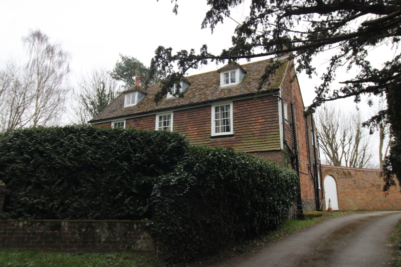
ASH-CUM-RIDLEY THE STREET
1.
5280
TQ 66 SW 7/27 1.6.67 Attwood Place
II
2.
C18. Two storeys and attics. Ground floor red brick on grey headers on a base
of flints. Above tile hung. Tiled roof with 3 hipped dormers. Three sashes
with glazing bars intact. Doorcase with pilasters, pediment and rectangular
fanlight.
Listing NGR: TQ6005964324
External links are from the relevant listing authority and, where applicable, Wikidata. Wikidata IDs may be related buildings as well as this specific building. If you want to add or update a link, you will need to do so by editing the Wikidata entry.


Other nearby listed buildings
