Approximate Location Map
Large Map »
Latitude: 51.1834 / 51°11'0"N
Longitude: 0.9396 / 0°56'22"E
OS Eastings: 605539
OS Northings: 146791
OS Grid: TR055467
Mapcode National: GBR SXQ.QCW
Mapcode Global: VHKKH.7JL5
Plus Code: 9F325WMQ+9R
Entry Name: 34, High Street
Listing Date: 16 February 1989
Grade: II
Source: Historic England
Source ID: 1216924
English Heritage Legacy ID: 411637
ID on this website: 101216924
Location: Wye, Ashford, Kent, TN25
County: Kent
District: Ashford
Civil Parish: Wye with Hinxhill
Built-Up Area: Wye
Traditional County: Kent
Lieutenancy Area (Ceremonial County): Kent
Tagged with: Building
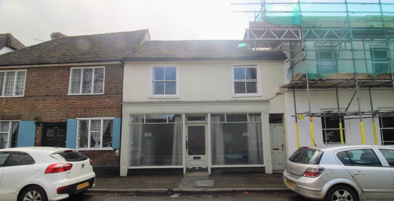
TR 0446 0546 WYE HIGH STREET
(south side)
8/254 No. 34
GV II
House and shop. C18, altered C19/C20. Painted brick with plain tiled roof.
Two storeys, with modillion bracketed eaves to roof with stacks to rear.
Two sashes on 1st floor and plate glass shop front over whole ground
floor, with central glazed door with fanlight. Four panelled door to end
right with rectangular fanlight. Included for group value.
Listing NGR: TR0553946791
External links are from the relevant listing authority and, where applicable, Wikidata. Wikidata IDs may be related buildings as well as this specific building. If you want to add or update a link, you will need to do so by editing the Wikidata entry.


Other nearby listed buildings
