Approximate Location Map
Large Map »
Latitude: 52.3381 / 52°20'17"N
Longitude: -2.2774 / 2°16'38"W
OS Eastings: 381197
OS Northings: 271151
OS Grid: SO811711
Mapcode National: GBR 0C0.F13
Mapcode Global: VH920.GHWG
Plus Code: 9C4V8PQF+62
Entry Name: 2 and 3, Lichfield Street
Listing Date: 5 July 1950
Grade: II
Source: Historic England
Source ID: 1217811
English Heritage Legacy ID: 393348
ID on this website: 101217811
Location: Stourport-on-Severn, Wyre Forest, Worcestershire, DY13
County: Worcestershire
District: Wyre Forest
Civil Parish: Stourport-on-Severn
Built-Up Area: Stourport-on-Severn
Traditional County: Worcestershire
Lieutenancy Area (Ceremonial County): Worcestershire
Church of England Parish: Stourport-on-Severn and Wilden
Church of England Diocese: Worcester
Tagged with: Building
STOURPORT ON SEVERN
SO8171SW LICHFIELD STREET
589-1/9/41 (North side)
05/07/50 Nos.2 AND 3
GV II
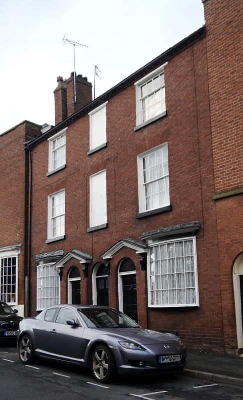
Pair of houses. c1800. Brick with heavy Welsh slate roof.
3-storeyed, 3 bays, the central bay containing round-arched
entry to passage with blind windows above. It is flanked by
doorways with open pediments, blind tympana and 6-panelled
doors, projecting from the building line. 16- and 12-pane
sashes above with flat arched brick heads and stone sills.
Modillion eaves cornice, gable end stacks.
Listing NGR: SO8119771151
External links are from the relevant listing authority and, where applicable, Wikidata. Wikidata IDs may be related buildings as well as this specific building. If you want to add or update a link, you will need to do so by editing the Wikidata entry.


Other nearby listed buildings
