Approximate Location Map
Large Map »
Latitude: 52.3378 / 52°20'15"N
Longitude: -2.2767 / 2°16'36"W
OS Eastings: 381245
OS Northings: 271112
OS Grid: SO812711
Mapcode National: GBR 0C0.F6Q
Mapcode Global: VH920.HH8Q
Plus Code: 9C4V8PQF+48
Entry Name: 9, Lichfield Street
Listing Date: 3 April 1970
Grade: II
Source: Historic England
Source ID: 1292267
English Heritage Legacy ID: 393351
ID on this website: 101292267
Location: Stourport-on-Severn, Wyre Forest, Worcestershire, DY13
County: Worcestershire
District: Wyre Forest
Civil Parish: Stourport-on-Severn
Built-Up Area: Stourport-on-Severn
Traditional County: Worcestershire
Lieutenancy Area (Ceremonial County): Worcestershire
Church of England Parish: Stourport-on-Severn and Wilden
Church of England Diocese: Worcester
Tagged with: Building
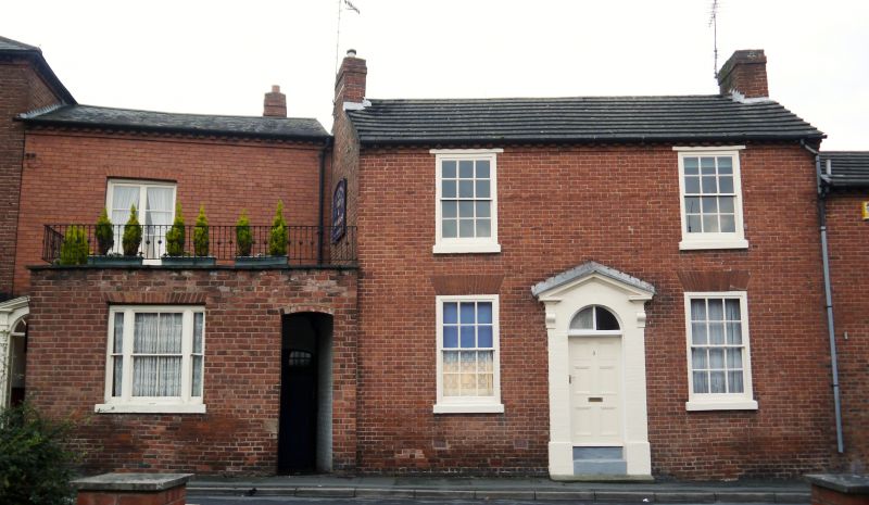
STOURPORT ON SEVERN
SO8171SW LICHFIELD STREET
589-1/9/44 (North side)
03/04/70 No.9
GV II
House. c1820. Brick with concrete tiled roof. 2-storeyed, 2
bays with central 6-panelled door with round arched fanlight
in open pedimented case flanked by 12-pane sashes with flat
arched gauged brick heads. Dentilled eaves band, gable end
stacks.
Listing NGR: SO8124571111
External links are from the relevant listing authority and, where applicable, Wikidata. Wikidata IDs may be related buildings as well as this specific building. If you want to add or update a link, you will need to do so by editing the Wikidata entry.


Other nearby listed buildings
