Approximate Location Map
Large Map »
Latitude: 52.4558 / 52°27'20"N
Longitude: -1.1994 / 1°11'57"W
OS Eastings: 454502
OS Northings: 284503
OS Grid: SP545845
Mapcode National: GBR 8PP.3KN
Mapcode Global: VHCTD.5J9R
Plus Code: 9C4WFR42+87
Entry Name: The Shambles Public House
Listing Date: 11 January 1955
Last Amended: 30 September 1993
Grade: II
Source: Historic England
Source ID: 1218008
English Heritage Legacy ID: 392549
Also known as: Shambles Inn
The Shambles Inn, Lutterworth
ID on this website: 101218008
Location: Lutterworth, Harborough, Leicestershire, LE17
County: Leicestershire
District: Harborough
Civil Parish: Lutterworth
Built-Up Area: Lutterworth
Traditional County: Leicestershire
Lieutenancy Area (Ceremonial County): Leicestershire
Church of England Parish: Lutterworth St Mary
Church of England Diocese: Leicester
Tagged with: Pub Thatched pub
LUTTERWORTH
BELL STREET
SP5484
1323-0/9/88 (East side)
11/01/55 The Shambles Public House
(Formerly Listed as:
BELL STREET
Nos.10 AND 12)
GV II
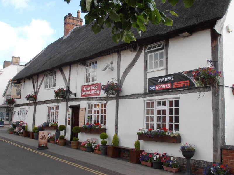
House, now public house. Early C16, restored in later C20.
Large square-panelled timber-framing with some curved braces
above, exposed with plaster infilling. Thatched roof. Range of
four units in series, The roof over two (possibly three) of
these units is smoke-blackened even though the partitions
between them are integral and rise through from ground to roof
apex; this suggests that the building originally comprised
various self-contained units, possibly workshops; 2 storeys
with stack to left end of ridge. Irregular fenestration of
three windows on first floor and four on ground floor, all C20
wooden casements. Boarded door to right of centre. Extensive
later C20 extensions to rear. Interior: ground floor much
altered; framed partitions survive as does the side-purlin
roof with curved wind braces, and queen posts over collar. At
the time of inspection smoke-blackened thatch still survived
on the underside of the roof, along with sooted principals and
rafters.
Listing NGR: SP5449784507
External links are from the relevant listing authority and, where applicable, Wikidata. Wikidata IDs may be related buildings as well as this specific building. If you want to add or update a link, you will need to do so by editing the Wikidata entry.


Other nearby listed buildings
