Approximate Location Map
Large Map »
Latitude: 51.4904 / 51°29'25"N
Longitude: -2.7681 / 2°46'5"W
OS Eastings: 346769
OS Northings: 177107
OS Grid: ST467771
Mapcode National: GBR JH.K8FZ
Mapcode Global: VH7BW.YSZV
Plus Code: 9C3VF6RJ+5Q
Entry Name: Fircliff House
Listing Date: 13 May 1981
Grade: II
Source: Historic England
Source ID: 1220297
English Heritage Legacy ID: 394047
ID on this website: 101220297
Location: Woodhill, North Somerset, BS20
County: North Somerset
Civil Parish: Portishead
Built-Up Area: Portishead
Traditional County: Somerset
Lieutenancy Area (Ceremonial County): Somerset
Tagged with: House
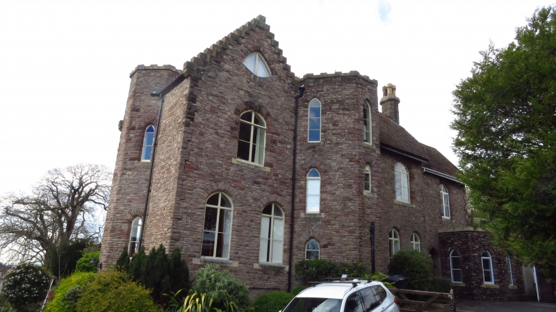
1.
5121 FIRCLIFF PARK
Nos 2 and 3
(Fircliff House)
ST 4677 2/11 13.5.81
II
2.
Late C19. Coursed squared rubble, tiled roof. Asymmetrical "E" front:
2 and 3 storeys, 3 and 5 windows all pointed; battlemented parapet to turret;
crow-stepped gable at south end, containing spherical triangle window. West
front of 2 storeys with 3 storey battlemented towers, bay projections.
Listing NGR: ST4676977107
External links are from the relevant listing authority and, where applicable, Wikidata. Wikidata IDs may be related buildings as well as this specific building. If you want to add or update a link, you will need to do so by editing the Wikidata entry.


Other nearby listed buildings
