Approximate Location Map
Large Map »
Latitude: 54.1335 / 54°8'0"N
Longitude: -0.7989 / 0°47'56"W
OS Eastings: 478577
OS Northings: 471518
OS Grid: SE785715
Mapcode National: GBR QNVN.V0
Mapcode Global: WHFBG.PCSJ
Plus Code: 9C6X46M2+CC
Entry Name: Warehouse Approximately 80 Metres South of Number 37, on Owston's Wharf
Listing Date: 15 June 1979
Last Amended: 5 April 1993
Grade: II
Source: Historic England
Source ID: 1220630
English Heritage Legacy ID: 389602
ID on this website: 101220630
Location: Malton, North Yorkshire, YO17
County: North Yorkshire
District: Ryedale
Civil Parish: Malton
Built-Up Area: Malton
Traditional County: Yorkshire
Lieutenancy Area (Ceremonial County): North Yorkshire
Church of England Parish: New Malton St Michael
Church of England Diocese: York
Tagged with: Warehouse
MALTON
SE780715 YORKERSGATE
801-1/8/180 (South side (off))
15/06/79 Warehouse approx. 80m S of No.37, on
Owston's Wharf
(Formerly Listed as:
YORKERSGATE
(South side)
Warehouse at Owston's Wharf behind
Nos. 33 and 35)
GV II
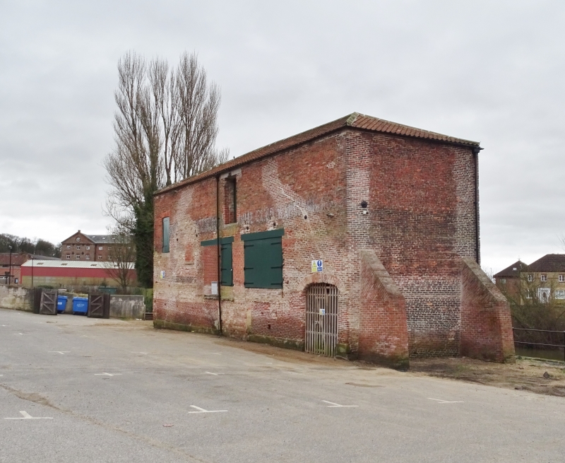
Warehouse. Late C18; re-roofed and altered later. Red brick in
English garden-wall bond, with stone dressings and hipped roof
of corrugated pantiles. Rectangular on plan, 7 bays. River
front: 3 storeys 3 windows, largely obscured by vegetation.
Wide segment-arched entrance in centre, between 2-light
windows with segmental arches. Upper-floor windows, of 2
lights, have flat arches of gauged brick. Yard front: 2
storeys, with irregular openings. Ground-floor openings
altered. At left end, wooden steps lead to plank door in
rebated opening with flat arch of gauged brick. In centre,
board lifting door beneath stone lintel. The building is the
last surviving one in Malton associated with the flourishing
commercial traffic conducted on the River Derwent following
the passage of the Derwent Navigation Act in 1702. A postcard
photograph of probably late C19 date shows the warehouse to be
occupied by ?Black and Co., Agricultural Seed merchants.
(In Old Picture Postcards: Stone J T: Malton, Norton and Old
Malton in Old Picture Postcards: Zaltbommel/Netherlands:
1983-: 33).
Listing NGR: SE7857771518
External links are from the relevant listing authority and, where applicable, Wikidata. Wikidata IDs may be related buildings as well as this specific building. If you want to add or update a link, you will need to do so by editing the Wikidata entry.


Other nearby listed buildings
