Latitude: 50.7192 / 50°43'9"N
Longitude: -3.5369 / 3°32'13"W
OS Eastings: 291598
OS Northings: 92188
OS Grid: SX915921
Mapcode National: GBR P0.QB8X
Mapcode Global: FRA 37G5.RW6
Plus Code: 9C2RPF97+M6
Entry Name: Exe Bridge Balustrades and Arch
Listing Date: 29 January 1953
Grade: II
Source: Historic England
Source ID: 1222693
English Heritage Legacy ID: 418115
ID on this website: 101222693
Location: The Quay, Exeter, Devon, EX4
County: Devon
District: Exeter
Electoral Ward/Division: St David's
Parish: Non Civil Parish
Built-Up Area: Exeter
Traditional County: Devon
Lieutenancy Area (Ceremonial County): Devon
Church of England Parish: Exeter St Mary Steps
Church of England Diocese: Exeter
Tagged with: Bridge
NEW BRIDGE STREET
1.
1092
(South-east Side)
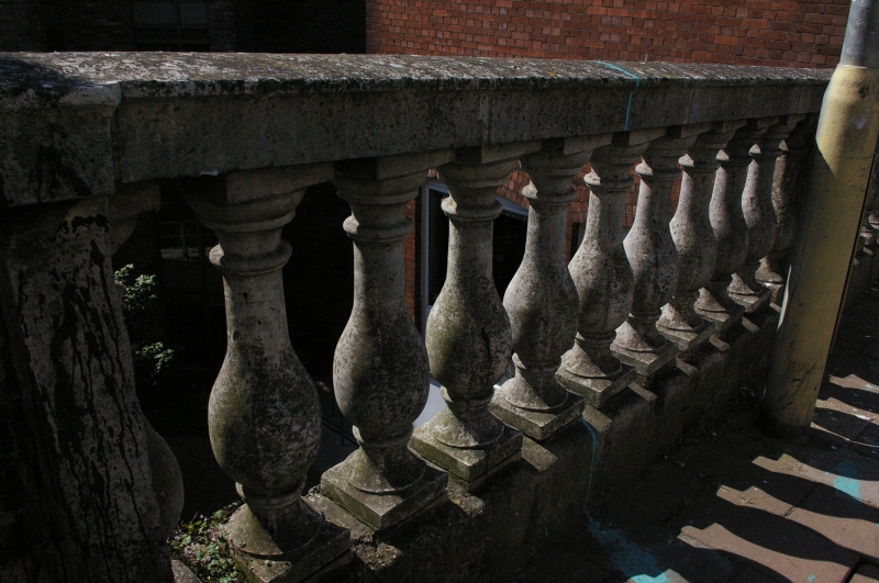
Exe Bridge Balustrades
and Arch
SX 9192 SE 5/148 29.1.53
II
2.
New Bridge Street embankment was formed when the C18 bridge was built (1770- 1776,
Architects Dixon and, later Godwin). Two lengths of balustrade remain on the New
Bridge Street embankment, also a segmental arch connecting Frog Street with Exe
Island and carrying the roadway. These are of interest because they are of similar
design to the bidge itself, which was demolished when the present bridge was built
in 1904.
Listing NGR: SX9159892188
External links are from the relevant listing authority and, where applicable, Wikidata. Wikidata IDs may be related buildings as well as this specific building. If you want to add or update a link, you will need to do so by editing the Wikidata entry.


Other nearby listed buildings