Approximate Location Map
Large Map »
Latitude: 51.1267 / 51°7'36"N
Longitude: 0.2597 / 0°15'34"E
OS Eastings: 558221
OS Northings: 138813
OS Grid: TQ582388
Mapcode National: GBR MPZ.6GS
Mapcode Global: VHHQD.GY43
Plus Code: 9F3247G5+MV
Entry Name: 17, Chapel Place
Listing Date: 7 June 1974
Grade: II
Source: Historic England
Source ID: 1223609
English Heritage Legacy ID: 167944
ID on this website: 101223609
Location: Royal Tunbridge Wells, Tunbridge Wells, Kent, TN1
County: Kent
District: Tunbridge Wells
Electoral Ward/Division: Pantiles and St Mark's
Parish: Non Civil Parish
Built-Up Area: Royal Tunbridge Wells
Traditional County: Kent
Lieutenancy Area (Ceremonial County): Kent
Church of England Parish: Tunbridge Wells King Charles the Martyr
Church of England Diocese: Rochester
Tagged with: Building
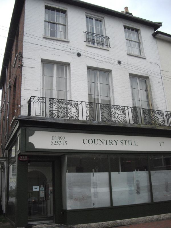
CHAPEL PLACE
1.
1746
(South East Side)
No 17
TQ 5838 NW 1/21
II GV
2.
Circa 1840. 3 storeys painted brick. Eaves cornice. 3 sashes. Iron balcony
on 1st floor. Quite a good contemporary shop front beneath it with the window
built in sections which remove. Side elevation of red brick. Doorcase with
wooden hood and console brackets and rectangular fanlight.
Nos 11 to 19 (odd) form a group.
Listing NGR: TQ5823038810
External links are from the relevant listing authority and, where applicable, Wikidata. Wikidata IDs may be related buildings as well as this specific building. If you want to add or update a link, you will need to do so by editing the Wikidata entry.


Other nearby listed buildings
