Approximate Location Map
Large Map »
Latitude: 51.1267 / 51°7'36"N
Longitude: 0.2597 / 0°15'34"E
OS Eastings: 558220
OS Northings: 138807
OS Grid: TQ582388
Mapcode National: GBR MPZ.6GT
Mapcode Global: VHHQD.GY44
Plus Code: 9F3247G5+MV
Entry Name: 19, Chapel Place
Listing Date: 7 June 1974
Grade: II
Source: Historic England
Source ID: 1346466
English Heritage Legacy ID: 167945
ID on this website: 101346466
Location: Royal Tunbridge Wells, Tunbridge Wells, Kent, TN1
County: Kent
District: Tunbridge Wells
Electoral Ward/Division: Pantiles and St Mark's
Parish: Non Civil Parish
Built-Up Area: Royal Tunbridge Wells
Traditional County: Kent
Lieutenancy Area (Ceremonial County): Kent
Church of England Parish: Tunbridge Wells King Charles the Martyr
Church of England Diocese: Rochester
Tagged with: Building
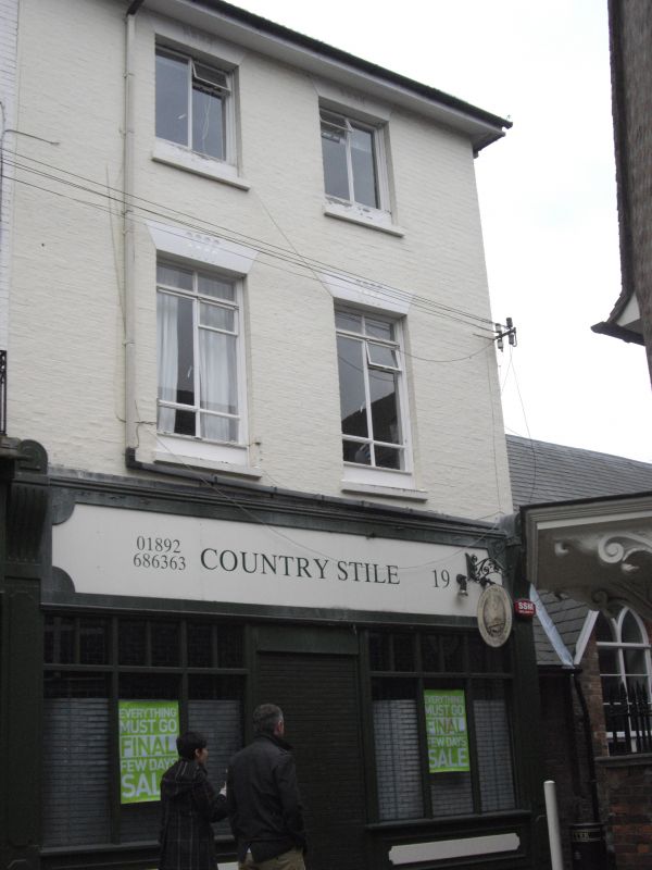
CHAPEL PLACE
1.
1746
(South East Side)
No 19
TQ 5838 NW 1/153
II GV
2.
Mid C19. 3 storeys painted brick. Wide eaves cornice. 2 altered windows with
fluted keystones. Mid C19 shopfronts.
Nos 11 to 19 (odd) form a group.
Listing NGR: TQ5822738803
External links are from the relevant listing authority and, where applicable, Wikidata. Wikidata IDs may be related buildings as well as this specific building. If you want to add or update a link, you will need to do so by editing the Wikidata entry.


Other nearby listed buildings
