Approximate Location Map
Large Map »
Latitude: 51.5092 / 51°30'33"N
Longitude: -0.1528 / 0°9'10"W
OS Eastings: 528287
OS Northings: 180534
OS Grid: TQ282805
Mapcode National: GBR 9F.V5
Mapcode Global: VHGQZ.9BKD
Plus Code: 9C3XGR5W+MV
Entry Name: 79, Mount Street W1
Listing Date: 1 December 1987
Grade: II
Source: Historic England
Source ID: 1223622
English Heritage Legacy ID: 419387
ID on this website: 101223622
Location: Mayfair, Westminster, London, W1K
County: London
District: City of Westminster
Electoral Ward/Division: West End
Parish: Non Civil Parish
Built-Up Area: City of Westminster
Traditional County: Middlesex
Lieutenancy Area (Ceremonial County): Greater London
Church of England Parish: St George, Hanover Square
Church of England Diocese: London
Tagged with: Building
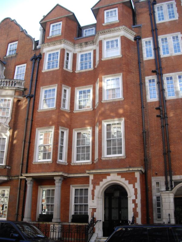
TQ 2880 NW CITY OF WESTMINSTER MOUNT STREET, W1
68/81 (south side)
No. 79
G.V. II
Terrace house. 1892-94 by Balfour and Turner. Red brick with
Portland stone dressings, slate roof. Free Style Queen Anne, a
restrained variant on No. 5 Aldford Street q.v. 4 storeys, basement
and gabled attics. 3 windows wide. Entrance in enclosed porch with
semicircular arched opening having 3 orders of mouldings with slender
jamb shafts, imposts and stepped voussoirs. Above rises a 3 storey
narrow canted bay balanced to left by a similar 3 storey canted bay
carried on octagonal stone columns with rather Byzantine foliated
caps, set in front of ground floor window. Narrow centre has single
sash window to each floor identical with sashes of canted bays whose
outer flanks are blind, all have glazing bars and shallow architraves.
Crisply profiled stone string over ground floor, stone entablature
carved above 3rd floor round the bays which are extended up into attic
and finished with plain gables; dormer to centre above short link
section of parapet. Arts and Crafts cast iron area railings. Part of
island block development by Balfour and Turner as part of their
Grosvenor Estate improvements.
Survey of London; Vol. XL.
Listing NGR: TQ2828780534
External links are from the relevant listing authority and, where applicable, Wikidata. Wikidata IDs may be related buildings as well as this specific building. If you want to add or update a link, you will need to do so by editing the Wikidata entry.


Other nearby listed buildings
