Approximate Location Map
Large Map »
Latitude: 51.8094 / 51°48'33"N
Longitude: -1.6359 / 1°38'9"W
OS Eastings: 425196
OS Northings: 212372
OS Grid: SP251123
Mapcode National: GBR 5SW.F79
Mapcode Global: VHBZS.LSH8
Plus Code: 9C3WR957+QJ
Entry Name: Warwick House
Listing Date: 12 September 1955
Grade: II
Source: Historic England
Source ID: 1223728
English Heritage Legacy ID: 419554
ID on this website: 101223728
Location: Burford, West Oxfordshire, OX18
County: Oxfordshire
District: West Oxfordshire
Civil Parish: Burford
Built-Up Area: Burford
Traditional County: Oxfordshire
Lieutenancy Area (Ceremonial County): Oxfordshire
Church of England Parish: Burford
Church of England Diocese: Oxford
Tagged with: House
BURFORD AND UPTON HIGH STREET
AND SIGNET (East Side)
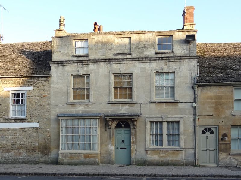
SP2512 (Enlargement) No 25 (Warwick House)
7/56
12.9.55
GV II
House. Front appears c.1800 (it is deceptive however as some of the
detail is the local c.1730 style), rear partly C16 (restored). Ashlar
front, Cotswold stone roof. L-plan. 2 storeys and attic; plinth, and
cornice (c.1730 style) below built-up attic with quatrefoil gutter outlets
at each return. 3 bays, glazing bar sashes, raised flat architraves with
keystones to 1st and ground floors, the ground floor right-hand window a
pair, the ground floor left-hand a small rectangular bay glazing-bar shop
front with frieze extending left and also right over central doorway.
Latter has arched flat surround with stone brackets to former stone hood,
Y-tracery fanlight, 6-panel (raised and fielded) door. Small irregular
attic windows. the C16 timber-framed stair turret at rear has been
rebuilt not keeping all the original timber; later C18 stairs with tall
window; South front noon has exposed a panel of probably C17 stencil
work.
Listing NGR: SP2519612372
External links are from the relevant listing authority and, where applicable, Wikidata. Wikidata IDs may be related buildings as well as this specific building. If you want to add or update a link, you will need to do so by editing the Wikidata entry.


Other nearby listed buildings
