Approximate Location Map
Large Map »
Latitude: 51.8092 / 51°48'33"N
Longitude: -1.636 / 1°38'9"W
OS Eastings: 425192
OS Northings: 212350
OS Grid: SP251123
Mapcode National: GBR 5SW.F7C
Mapcode Global: VHBZS.LSGF
Plus Code: 9C3WR957+MJ
Entry Name: The Burford Woodroom
Listing Date: 12 September 1955
Last Amended: 1 March 1990
Grade: II
Source: Historic England
Source ID: 1223730
English Heritage Legacy ID: 419557
ID on this website: 101223730
Location: Burford, West Oxfordshire, OX18
County: Oxfordshire
District: West Oxfordshire
Civil Parish: Burford
Built-Up Area: Burford
Traditional County: Oxfordshire
Lieutenancy Area (Ceremonial County): Oxfordshire
Church of England Parish: Burford
Church of England Diocese: Oxford
Tagged with: Architectural structure Shop
BURFORD AND UPTON HIGH STREET
AND SIGNET (East Side)
SP2512 (Enlargement) No 31 (The Burford
7/59 Woodroom) (Previously
12.9.55 listed as part of
premises on NW corner of
Church Lane and House
adjoining on North)
GV II
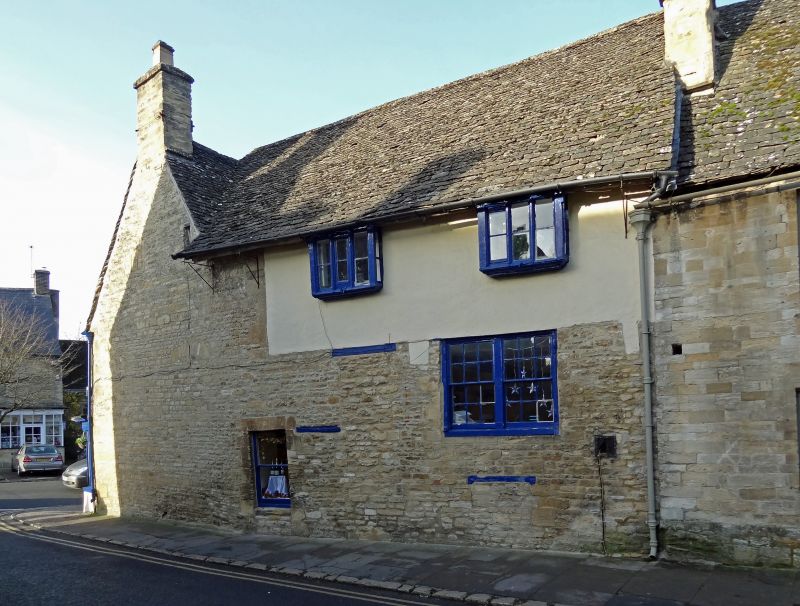
House. Probably C16 with C17 front, remodelled in C19. Roughcast
projecting timber-frame 2-storey front on rubble house with Cotswold stone
roof, rubble gable end chimneys. Plan: 3 room, 2 in front and one to
rear. 2 storeys and attic with roof-lights; 2 windows, casements, on 1st
floor, continuous mid-C19 shop-front on ground floor with dentil cornice
to fascia and 2 doors. Gable end to south has blocked 2-light cusped head
window to attic and a very small wood-framed light. 2-storey return to
Church Street with plastered timber frame on 1st floor, 2 square 1st floor
oriel bay windows with wooden ovolo mullions to 3-light windows; ground
floor altered, 2 windows, irregular to left, right-hand paired bar sashes
over a C17 timber lintel. Interior: 1st floor South room has early C18
raised and fielded panelling, East room has two jowled post trusses, one
with braces. The roof has tie and collar trusses with square ridge and
evidence of smoke blackening.
Shown as No 18A on OS map.
Listing NGR: SP2519212350
External links are from the relevant listing authority and, where applicable, Wikidata. Wikidata IDs may be related buildings as well as this specific building. If you want to add or update a link, you will need to do so by editing the Wikidata entry.


Other nearby listed buildings
